2026:195 - Ballygullen, Kilnahue, Gorey, Wexford
County: Wexford
Site name: Ballygullen, Kilnahue, Gorey
Sites and Monuments Record No.: WX006-086----
Licence number: 26E0487
Author: Michael Greiner & Seán Shanahan; Shanarc Archaeology Ltd.
Author/Organisation Address: Unit 39a, Hebron Business Park, Hebron Road, Kilkenny
Site type: Battlefield; no archaeology found
Period/Dating: N/A
ITM: E 710506m, N 661607m
Latitude, Longitude (decimal degrees): 52.694314, -6.365195
Archaeological test-excavations were carried out on 3 July 2026, as part of an Archaeological Impact Assessment relating to the proposed development of a private dwelling house and domestic garage on a c. 0.3-hectare agricultural greenfield plot at Ballygullen (Kilnahue ed), Gorey, Co. Wexford.
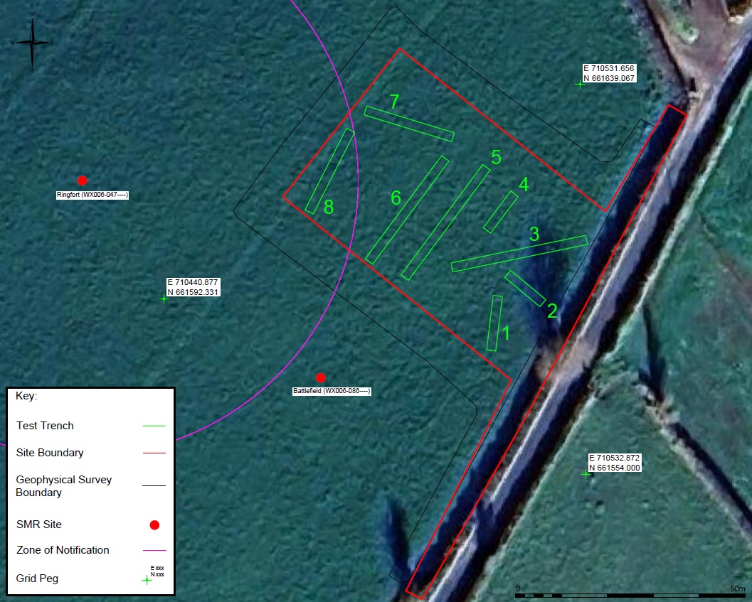
The wider containing field is the recorded location of a battlefield (WX006-086—-). Additionally, a ringfort (WX006-047—-) is recorded c. 20–40m to the west of the development area, and the associated Zone of Notification (Zone ID: R146454) extends within the western limits of the development area.
A further information request from Wexford County Council in relation to the planning application stipulated that the site be subjected to an archaeological assessment, which was to include a geophysical survey, a metal detection survey, and targeted test-excavation.
The associated geophysical survey of the site was carried out by Shanarc Archaeology Ltd., in April 2026 under survey licence no. 26R0209. The geophysical survey identified multiple potential archaeological features primarily in the form of possible pit-type features.
Testing comprised the excavation of eight targeted test-trenches. The test-trenches were 2m in width, and ranged in length from 10–30m, with maximum depths ranging from c. 0.25–0.38m. The test-trenches were targeted on the proposed development footprint, and on those anomalies identified as potential archaeology during the preceding geophysical survey.
The stratigraphy of the excavated material was consistent across all trenches, comprising c. 0.11m of sod, overlying c. 0.14–0.26m of a moderately compact light-brown, sandy, silty, topsoil with a frequent amount of small-sized angular stones. The topsoil overlay natural subsoil comprising a moderately compact, light orange-brown sandy silt with frequent small-sized angular stones (shale).
None of the anomalies identified as potential archaeology in the geophysical survey data were found to be archaeological in nature; in so far as any of the investigated anomalies were visible within the excavated trenches, these simply related to natural accumulations of stone (shale) within the subsoil.
No archaeological finds, features, or deposits were identified in any of the excavated test-trenches.
Concurrently with the test-excavations, the excavated material and the area immediately surrounding each of the trenches was subjected to a metal detection survey, under detection licence no. 26R0274. No objects/finds were identified during the metal detection survey.