2026:284 - St Mary's Church, Delvin, Westmeath
County: Westmeath
Site name: St Mary's Church, Delvin
Sites and Monuments Record No.: WM014-003001-
Licence number: C001515; E005912
Author: Steven McGlade
Author/Organisation Address: Archaeology Plan, 129 North Strand Road, Dublin 3, D03W8C1
Site type: Monitoring
Period/Dating: Medieval (AD 400-AD 1600)
ITM: E 659931m, N 762697m
Latitude, Longitude (decimal degrees): 53.610676, -7.094334
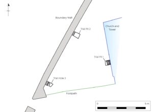
Three hand-dug trial holes were excavated within the graveyard (WM014-003001-) of St Mary’s Church, Delvin, Co. Westmeath. The trial holes were inserted to investigate potential solutions for repairs to the graveyard boundary wall to the west, which is in danger of collapse. The trial holes were inserted in the level area between the medieval tower and the western boundary wall. No gravestones were present within this part of the graveyard.
The three trial holes demonstrated that similar deposits are present across this part of the graveyard. The upper deposit was the current sod layer. It overlay a mixed deposit that included disarticulated human bone along with red brick and mortar fragments and 19th-20th-century glass and other materials. It is unknown when this material was deposited across the area. It may relate to one of the phases of construction in the 19th century, or to other works associated with the boundary wall. The lower deposit appears to be the original graveyard soil. While occasional disarticulated bone was noted it was not as rich as more extensively used burial grounds.
One trial hole was opened at the base of the medieval tower (WM014-003—) forming the western end of the church. The slightly sloping western façade of the tower continued down to its foundations, which had three slight steps at 380mm, 480mm and 940mm below present ground level (PGL), extending 0.31-0.4m out from the base of the wall at PGL. The base of the tower wall foundation was not reached within the trial hole.
Two trial holes were inserted along the internal side of the graveyard boundary wall. The wall had uneven steps, or was unfaced, below PGL to its east. The upper step was 200-280mm below PGL, extending 180-270mm to the east of the wall façade. A second step was encountered in the southern Trial hole 3, which was 580mm below PGL and extended 500mm from the wall façade.
The western section of the wall was surveyed during the works. When compared with the c. 1830’s First Edition Ordnance Survey map, a slight kink in the graveyard wall is apparent on the mapped wall to the north of the east-west path leading to the church, which does not appear to be reflected in the current wall. The kink is also clearly depicted on the c. 1910’s Ordnance Survey map. We were informed during the works that Westmeath County Council had carried out realignment works to the wall in the 1970s.
No in-situ burials were identified within the trial holes. It should not be assumed that burials are not present elsewhere within this space.
Natural subsoil was not encountered within any of the trial holes.