2026:092 - Fore, Westmeath
County: Westmeath
Site name: Fore
Sites and Monuments Record No.: WM004-035014-
Licence number: 26E0309
Author: Steven McGlade
Author/Organisation Address: Archaeology Plan, 129 North Strand Road, Dublin 3, D03W8C1
Site type: Monitoring
Period/Dating: N/A
ITM: E 651552m, N 770223m
Latitude, Longitude (decimal degrees): 53.679193, -7.219694
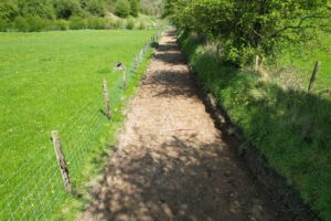
A programme of archaeological monitoring was undertake during the widening of a path associated with the walking circuit around Fore, Co. Westmeath. The northern section of the path lies within the constraint zone for the motte and bailey (WM004-035014-). The path widening works involved the stripping out of the original path, c. 1m in width, and the laying of a new surface c. 3.2m in width. The new surface was gravel laid on Terram. A new post and wire fence was erected to the west of the path.
The path was initially stripped, however the works did not require that subsoil be reached. Subsoil was not encountered along the majority of the path, and where present, no earlier cut features were identified. No archaeological features or deposits were identified during the works, though features may be present at a lower level as the subsoil has not been inspected for potential archaeological features below the level of the path.