
2026:198 - Commons of Lloyd, Meath
County: Meath
Site name: Commons of Lloyd
Sites and Monuments Record No.: ME016-054---
Licence number: E004569
Author: Niall Roycroft
Author/Organisation Address: c/o Meath County Council, Buvinda House, Dublin Road, Navan, Co Meath. C15 Y291.
Site type: Hillfort
Period/Dating: Multi-period
ITM: E 672214m, N 776494m
Latitude, Longitude (decimal degrees): 53.733091, -6.905541
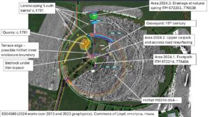
The People’s Park, Commons of Lloyd, Kells includes Hillfort RMP ME016-054— and the Protected Structure Spire of Lloyd MH016-123/NIAH 1441601, within its partially surviving 18th-century landscape area. The hilltop also includes a pauper’s burial ground associated with the Kells Workhouse, 1840s to 1921.
In 2024 Meath County Council constructed Area 2024.1 Footpath which was 1.4m wide x 8m long x 100mm max deep. The footpath was required due to the popularity of the tours now going up the Spire of Lloyd and a path between the upper carpark and the northern access stairs to the tower was required.
The footpath basically removed the turf and spitted a limited excavation into the soil below. In this soil was modern litter and a large piece of apparently in-situ tarmac (partially exposed but reburied as it was below project level) from the original upper carpark. It was clear that the topsoil was modern landscaping – probably from the 1980s – that had created an even-shaped mound around the tower base. However, exposed bedrock was seen in a gritted gully-apron around the tower base, so the bedrock does seem to be uneven in the area. This area had already been impacted by a modern services box and underground services. The gritted area around the tower base was filled with clause 804 material and this was covered in modern chippings. A small area of tarmac path surfacing was used to level up the uneven base of the southern steps at the tower base. No artefacts were recovered.
Area 2024.2 was repaving the upper carpark and the access track. Pre-works survey showed apparently outcropping bedrock in the south-east carpark area. All existing material was left in situ and the new paving laid over it (proposed kerbing for the access track was not laid). This work did not require archaeological monitoring.
The excavation area was a 10.5 sq m field drain at Drainage Area 2024.3 ITM 672203, 776638 in a natural spring zone next to the 2023 Phase 3 fencing gate. This 10m long drain trench, 0.4m to 0.5m wide x 0.4m or so deep, cut through a small section of the 18th-century inner ditch and outer (partially stone-faced) bank to the site. The southern end of the drain was in a sump area 3.5m x 1.9m x 0.6m deep. The drain trench and pipe were lined with chippings and all soil was spread out for inspection.
The section of the 18th-century outer ‘Louth Bank’ site boundary showed it was 2.6m wide, 0.6m high internally and up to 2m high at the outer ditch (which was inaccessible). There were two layers in the bank: the lower a sterile light yellow-brown and the upper a slightly darker yellow-brown. The outer ditch showed signs of being fairly recently cleaned out as it is used as a watering hole for cattle using water from the natural spring. The stone-faced lower, outer side of the Louth Bank was seen to be a dry stone built wall 0.5m wide (visible 0.5m high in the 2024.3 section) into which hawthorn hedge planting had been set. The inner ditch was seen as an area containing many stones, but the actual ditch was not visible in the dry conditions. The green-grey subsoil of the spring area (recorded in 2023) was also not particularly visible in 2024 due to the dry conditions. All soils were excavated in shallow spits with a flat-bladed ditching bucket and no artefacts were recovered. As noted in 2023, the topsoil in this area was probably first ploughed in the 20th century when the common land was cleared in the 1930s.