2026:086 - Maynetown, Portmarnock South, Dublin
County: Dublin
Site name: Maynetown, Portmarnock South
Sites and Monuments Record No.: n/a
Licence number: 24E1233
Author: Gill McLoughlin
Author/Organisation Address: c/o Courtney Deery Heritage Consultancy, Unit 5B, Block F, Nutgrove Office Park, Rathfarnham, Dublin 14
Site type: Burnt mound trough and pit
Period/Dating: Bronze Age (2200 BC-801 BC)
ITM: E 723450m, N 741950m
Latitude, Longitude (decimal degrees): 53.413219, -6.143027
Archaeological monitoring was carried out relating to a permitted large-scale residential development (LRD) known as Portmarnock South Phase 1E.
The site is located in Maynetown townland, to the west of the Coast Road (R106) and the Baldoyle Estuary, north of the Mayne Road (R123) and to the east of the Dublin-Belfast Railway Line and the ‘St Marnock’s Bay’ residential development.
The archaeological monitoring of the Phase 1E development area followed a phased programme of archaeological investigations, desktop studies, geophysical surveys and excavations across the Portmarnock South lands where Phases 1A, 1B, 1C have been completed and Phase 1D was under construction at the time of the monitoring.
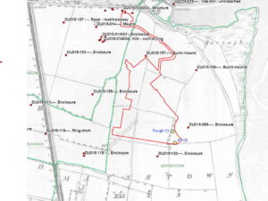
Recorded subsurface enclosures DU015-055 and DU015-130 are located immediately adjacent to the south-east corner of the Phase 1E development area to the southeast and south respectively and do not form part of Phase 1E development. No works were undertaken within the buffer zone of either of these monuments as part of the current development. Enclosure DU015-055 was surrounded by metal fencing and enclosure DU015-130, which was outside of the land ownership boundary, was demarcated from the Phase 1E development area using wooden post-and-rail fencing.
The monitoring was carried out between March and May 2025 and a trough and a small shallow pit, both containing heat-affected stone consistent with burnt mound activity, were identified during the course of topsoil removal. A sample of charcoal from the fill of the trough returned a date range of 3432 +/-24 BP, calibrated to BC 1873-1632, placing this activity towards the end of the early Bronze Age.