2026:068 - St Fergal's Boys National School, Cappagh Road, Finglas, Dublin 11, Dublin
County: Dublin
Site name: St Fergal's Boys National School, Cappagh Road, Finglas, Dublin 11
Sites and Monuments Record No.: DU014-066----
Licence number: 25E1146
Author: Philip Quilty & Thaddeus Breen; Shanarc Archaeology Ltd.
Author/Organisation Address: Unit 39a, Hebron Business Park, Hebron Road, Kilkenny
Site type: Excavation - miscellaneous
Period/Dating: Multi-period
ITM: E 712648m, N 738821m
Latitude, Longitude (decimal degrees): 53.387527, -6.306549
Archaeological test-excavations as part of an AIA were carried out on 13 January 2026, in relation to proposed development of a 2-storey extension to the rear of the school building at St Fergal’s Boys National School, Finglas, Dublin 11.
The development site is situated within the Zone of Archaeological Notification for the historic town of Finglas (DU014-066—-). The site lies in close proximity to several recorded monuments, including Cardiff’s Castle (DU014-066003-) approximately 28m to the north, King William’s Rampart (DU014-066008-) approximately 80m to the east, and the site of the medieval Archbishop’s residence at Fortwilliam/Springmount (DU014-066005-) approximately 120m to the east.
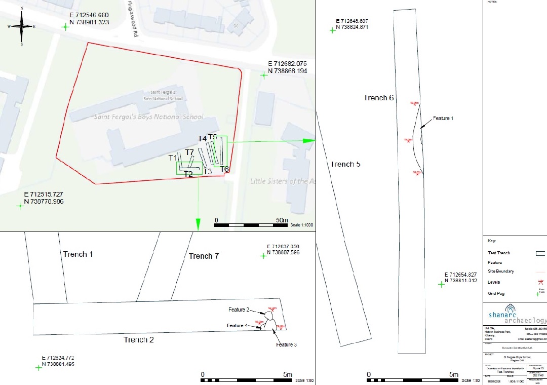
To address the archaeological potential of the development site, and to assess the impact of site development on potential sub-surface archaeological remains, a total of seven archaeological test-trenches were excavated, positioned to investigate the footprint of the proposed 2-storey extension and associated site works to the south-east of the existing school building.
Archaeological testing established that features of potential archaeological significance survive within the development area. In Trench 2, three inter-cutting features (F2, F3, F4) were identified at the western end of the trench. These features contained charcoal and burnt bone deposits consistent with prehistoric cremation burials. The features were sub-circular to sub-oval in plan, ranging from 0.35m to 0.6m in diameter.
The discovery of potential cremation deposits at this location is consistent with the broader archaeological landscape of Finglas. Analysis of LiDAR imagery identified a curvilinear anomaly to the south of the development site, the morphology of which is consistent with a ring-ditch, a class of monument typically associated with Bronze Age funerary activity. Ring-ditches represent the ploughed-out remains of round barrows, with the central burial mound having been levelled by centuries of agricultural activity, leaving only the surrounding ditch visible as a cropmark or subtle earthwork. While the precise date of the potential cremation deposits identified in Trench 2 cannot be determined without radiocarbon dating, their presence suggests that the development site may lie within, or adjacent to, a prehistoric funerary landscape that extends southward from the school grounds.
In Trench 6, a curvilinear feature (F1) was identified, measuring 4.43m by 0.58m and 0.18m deep. The fill consisted of a firm, greyish-brown clay with occasional small sub-angular stones. A single sherd of red-glazed pottery dating to the 17th–18th centuries was recovered from the fill. The curving nature of this feature may suggest it represents part of an enclosure ditch or field boundary of post-medieval date, potentially associated with the agricultural activity documented in the Civil Survey of 1654–56 and the subsequent cartographic record.
The remaining trenches (1, 3, 4, 5 and 7) revealed no features, finds or deposits of archaeological significance. Modern disturbance was evident across much of the site, with topsoil deposits containing 19th- and 20th-century material including whiteware pottery, brick fragments, glass, and seashells. The natural subsoil across the site consisted of green/yellow boulder clay.
The archaeological features identified in Trenches 2 and 6 lie outside of the footprint of the building extension. The potential cremation deposits in Trench 2 (F2, F3, F4) are located within an area originally designated for associated site works, but were subsequently covered with protective sheeting and cordoned off/fenced off from the development area, pending topsoil reinstatement and preserved in situ.