2026:326 - Knockgriffin, Midleton, Cork
County: Cork
Site name: Knockgriffin, Midleton
Sites and Monuments Record No.: N.A
Licence number: 26E0948
Author: Michael Greiner & Seán Shanahan; Shanarc Archaeology Ltd.
Author/Organisation Address: Unit 39a, Hebron Business Park, Hebron Road, Kilkenny
Site type: Pits and possible hearths
Period/Dating: Undetermined
ITM: E 586797m, N 575043m
Latitude, Longitude (decimal degrees): 51.927349, -8.191969
Archaeological test-excavations were carried out between 23 September and 6 October 2026, as part of an Archaeological Impact Assessment in relation to the proposed development of Phase 2 of an ongoing Large-scale Residential Development at Knockgriffin, Midleton, Co. Cork.
The c. 13.3-hectare greenfield site comprises five separate adjoining agricultural fields. There are no recorded SMR/RMP sites within the proposed development area or within an 800m radius of the site.
Prior to testing, a detailed geophysical survey was carried out by Shanarc Archaeology Ltd., in June 2026, under prospection licence no. 26R0282; a detailed geophysical survey report has been submitted to the National Monuments Service. The geophysical survey identified a relatively high number of potential archaeological features, primarily comprising potential pit-type features.
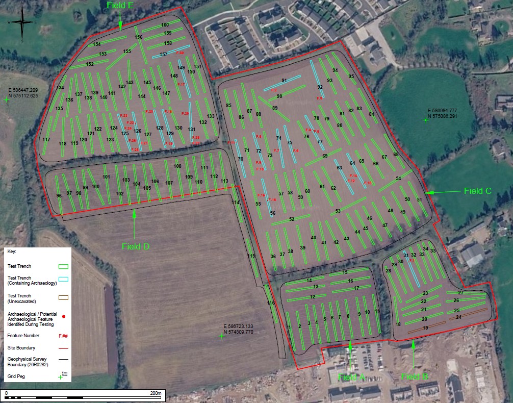
Testing comprised the excavation of 158 test-trenches across the site. Initially 160 test-trenches had been planned; however, the area containing proposed Trenches 19 & 24 was occupied by a spoil heap and extended boundary fencing associated with the neighbouring Phase 1 development at the time of testing, and for this reason these two trenches could not be excavated.
Where possible, test-trenches were targeted on those anomalies identified as potential archaeology in the geophysical survey data.
The excavated test-trenches were 2–2.22m in width, and ranged in length from 36–50m, with a maximum depth of 0.2–0.6m. The general stratigraphy comprised of a topsoil layer of a moderately compact, mid-brown silty sand with frequent small and medium-sized sub-angular and sub-rounded stones, and occasional large sub-angular and sub-rounded stones. The topsoil overlay natural subsoil, comprising a moderately compact, mid-orange-brown silty sand, with frequent small and medium-sized sub-angular and sub-rounded stones, and occasional large-sized sub-angular and sub-rounded stones.
In total, thirty archaeological and/or potential archaeological features (Features 1–30), were identified in eighteen of the excavated test-trenches;
- An area of scorched clay (Feature 1) was identified in Trench 31.
- Two possible pits with charcoal (Feature 15 & 16) were identified in Trench 56.
- An area of scorched clay (Feature 12) was identified in Trench 63.
- A possible pit with charcoal (Feature 13) was identified in Trench 64.
- An area of scorched clay (Feature 14) was identified in Trench 64.
- An area of scorched clay (Feature 11) was identified in Trench 70.
- Three areas of scorched clay (Features 8, 9, & 10) were found in Trench 72.
- An area of scorched clay (Feature 7) was found in Trench 74.
- An area of scorched clay (Feature 6) was found in Trench 75.
- Two pits (Features 4 & 5) were identified in Trench 77.
- An area of scorched clay (Feature 2) was identified in Trench 91.
- An area of scorched clay (Feature 3) was identified in Trench 92.
- Four features (Features 23, 24, 25, & 26) comprising areas of scorched clay and possible pits were identified in Trench 125.
- A possible pit (Feature 21) and an area of scorched clay (Feature 22) were identified in Trench 126.
- Two areas of scorched clay (Features 19 & 20) were identified in Trench 128.
- An area of scorched clay (Feature 18) was identified in Trench 129.
- Three areas of scorched clay (Features 27, 28, & 29) were identified in Trench 131.
- A possible pit (Feature 17) was identified in Trench 149.
- An area of scorched clay (Feature 30) was identified in Trench 157.
Of the thirty identified archaeological and/or potential archaeological features, eight features correlated with the locations of anomalies interpreted as potential archaeology in the geophysical survey data (Features 4, 6, 10, 14, 20, 23, 29 & 30), and two correlated with anomalies identified as probable ferrous in the geophysical survey data (Features 1 & 26). The remaining identified features did not match any specific anomalies highlighted in the geophysical survey data.
In addition to the various numbered archaeological and/or potential archaeological features, a number of linear features were also identified within multiple test-trenches; all the identified linear features correlated to former field boundaries and/or drains which were also identified in the geophysical survey data.
With the exception of a likely modern glass bottle base from Trench 29, and sherds of modern pottery from Trenches 11, 21, 22, 30, 31, 54, 73 & 138, there were no finds in any of the excavated test-trenches.