2026:158 - Adelaide Street/Grattan Street, Cork, Cork
County: Cork
Site name: Adelaide Street/Grattan Street, Cork
Sites and Monuments Record No.: CO074-034002-
Licence number: 26E0292
Author: David Murphy
Author/Organisation Address: 3a Westpoint Trade Centre, Link Road, Ballincollig, Cork
Site type: Town defences
Period/Dating: Late Medieval (AD 1100-AD 1599)
ITM: E 566928m, N 572100m
Latitude, Longitude (decimal degrees): 51.900070, -8.480570
A programme of archaeological testing was carried out at a proposed development site at Nos. 11 – 14 Adelaide Street, Cork in order to determine the location, alignment and depth of the medieval city wall of Cork (C0074-034002-) within the site. One exploratory test trench, measuring c. 6m east-north-east/west-south-west by 3m was opened in the south-western corner of the site, within an upstanding, 20th-century, single-storey workshop.
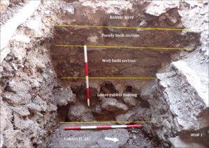
The testing programme revealed that the inner (eastern face) of the City Wall extended only marginally into the westernmost portion of the subject site, with the majority of the wall’s width extending below the public realm to the west of the site. The top of the wall was revealed at a depth of c. 0.4m below modern surface level.
The eastern face of the wall projected a maximum of 0.35m into the site as measured from the internal block wall of the extant workshop structure. There was a greater width of wall top evident on the southern side of the trench (0.24m wide), with the wall top running completely under the trench baulk at its northern side. As such, the city wall appeared to be veering more north-westerly as it progressed northwards.
Based on the evidence garnered from the testing programme, along with evidence from previous excavations in the immediate vicinity, the revealed section of the City Wall likely comprised a 17th-century rebuild, which potentially utilised masonry from the original 13th/14th-century city wall as a foundation footing.
The testing programme also demonstrated the presence of intact stratigraphy and other features such as post-medieval walls and culverts. The intact archaeological layers were sealed beneath the upper rubble infill layers and were revealed at a general depth of 0.5m to 0.6m below slab level. The post-medieval walls extended into the rubble infill layers and were revealed at depths of only 0.1m to 0.4m below slab level.