2025:493 - Ballynabrigadane, Ballymurn, Wexford
County: Wexford
Site name: Ballynabrigadane, Ballymurn
Sites and Monuments Record No.: N/A
Licence number: 24E0699
Author: Philip Quilty
Author/Organisation Address: Shanarc Archaeology Ltd, Unit 39A Hebron Business Park, Hebron Road, Kilkenny R95 KV08
Site type: Excavation
Period/Dating: Prehistoric (12700 BC-AD 400)
ITM: E 704702m, N 633170m
Latitude, Longitude (decimal degrees): 52.439965, -6.460001
Archaeological excavation was carried out commencing 12 December 2024, during development at the townlands of Ballynabrigadane and Ballylucas, Ballymurn, Co. Wexford.
The development works comprised the stripping of topsoil in advance of the extraction of sand at a permitted sandpit. The development of the sandpit will be carried out in phases, and the archaeological excavation took place across the southern part of the wider permitted sandpit, in Extraction Phase 1 – Area 1 and in part of Extraction Phase 2.
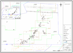
The archaeological site identified at Ballynabrigadane and Ballylucas has been divided into four main areas of activity: Areas A, B, C, and D. Areas A and B were in the townland of Ballynabrigadane, while Areas C and D were in the townland of Ballylucas. To date, four phases of activity (Phase I–IV) have been identified at the site; however, analysis is ongoing and this phasing may be further refined.
The earliest and most significant activity is Bronze Age in date (Phase I), consisting of fifteen structures (Structures A–N; Areas A and B), a small flat cremation cemetery (Area D), two burnt mounds (Areas C and D), a segmented field boundary system, and numerous pits and post-holes. The structures, measuring between 3m to 5m in diameter, are comprised of post- and stake-holes and represent domestic dwellings. A significant quantity of artefacts was recovered including prehistoric pottery (provisionally dated to the Middle Bronze Age), lithics (including three leaf-shaped arrowheads and a possible stone wrist-guard fragment), and stone objects. The cremation cemetery includes at least three burials, one containing an intact ceramic vessel (urn) filled with cremated human remains.
A relict field boundary (Phase II; Area C) dates to the 17th century based on ceramic evidence (North Devon gravel-free ware and Glazed Red Earthenware) and is not depicted on Ordnance Survey mapping. A series of relict field boundaries dating to the 19th century (Phase III; Areas A and D), depicted on the first edition Ordnance Survey mapping (1839–1841), were identified together with associated drains and agricultural furrows. Modern agricultural features and ground disturbance (Phase IV) were also present on site.
Post-excavation analysis including radiocarbon dating, paleoenvironmental assessment, ceramic analysis, lithic analysis, and specialist reporting is required to refine the chronology and interpretation of this significant multi-period site. The Bronze Age settlement represents one of the most substantial prehistoric occupation complexes excavated in County Wexford and makes important contributions to our understanding of Bronze Age society, economy, and landscape organization in south-eastern Ireland.