2025:505 - Mullingar Shamrocks GAA, Robinstown (Tyrrell), Westmeath
County: Westmeath
Site name: Mullingar Shamrocks GAA, Robinstown (Tyrrell)
Sites and Monuments Record No.: n/a
Licence number: 25E0326
Author: James Kyle
Author/Organisation Address: c/o ABH Ltd. Spade Enterprise Centre, Smithfield, Dublin 7.
Site type: Fulacht fiadh
Period/Dating: Bronze Age (2200 BC-801 BC)
ITM: E 644170m, N 753900m
Latitude, Longitude (decimal degrees): 53.533192, -7.333734
Archaeological testing on site uncovered two fulachtaí fiadh/burnt mound sites on the eastern side of a tributary stream of the River Brosna.
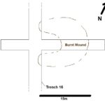
Site A (ITM: 644176, 753838) was located 18m south of the northern end of Trench 16, comprising a deposit of burnt mound-type material: heat-shattered stone in a charcoal rich black-brown silty clay deposit, which measured 15.2m north-east/south-west x 14m, with a depth of 0.21m, where sectioned. The mound was discernible as being a low, broadly horseshoe/U-shaped rise in the field surface, with the bulk of the material being to the northeast of the trench and oriented onto the tributary stream. Although no trough feature was encountered, the presence of such, whether wood-lined, clay or indeed stone, should not be ruled out. Trench 25 was excavated perpendicular to Trench 16 in order to facilitate a fuller appraisal of the deposit, which was located on top of a 0.2m in depth layer of peat, which in turn was above the smooth silty clay subsoil.
Site B (ITM: 644202, 753719) was located a further 27m south of Site A in Trench 16, adjacent to a single hawthorn tree. Again, the site comprised a deposit of burnt mound-type material: heat-shattered stone in a charcoal-rich black-brown silty clay deposit, which measured 20m east-west x 17m, with a depth of 0.18m, where sectioned.

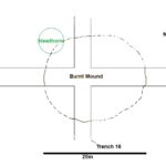
The mound was discernible as being roughly circular and adjacent to the tributary stream and although no trough feature was encountered the presence of such, whether wood-lined, clay or indeed stone, should not be ruled out. Trench 24 was excavated perpendicular to Trench 16 in order to facilitate a fuller appraisal of the deposit, which was again located on top of a 0.2m in depth layer of peat, which in turn was above the smooth silty clay subsoil.