2025:716 - MOYGADDY, Meath
County: Meath
Site name: MOYGADDY
Sites and Monuments Record No.: NA
Licence number: 25E0989
Author: Barry Lacey
Author/Organisation Address: c/o IAC Ltd, Unit G1 Network Enterprise Park, Kilcoole, Co. Wicklow
Site type: Various
Period/Dating: Multi-period
ITM: E 694324m, N 739296m
Latitude, Longitude (decimal degrees): 53.395383, -6.581772
A programme of archaeological testing was undertaken in advance of a proposed development within a 95ha site located at Moygaddy townland, Maynooth, County Meath. The assessment was informed by two programmes of geophysical survey conducted in 2019 and 2024 (Leigh 2019; 2024, Licence Nos. 19R0084, 24R0357).
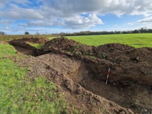
Archaeological testing was carried out over the course of five days from 20 November 2025 using a mechanical excavator fitted with a flat grading bucket. The trenches targeted geophysical anomalies and open green space in order to fully investigate the archaeological potential of the site. Trenches 40–44 in the south-east portion of the site could not be excavated due to inaccessibility associated with ongoing roadside infrastructure works. Testing revealed ten separate areas of archaeological significance, designated as AA1-10 comprising: four possible prehistoric ring-ditches (AA1, AA2, AA10); five pits (AA3, AA5, AA7, AA8); a spread of burnt material (Area 9); two large, possible prehistoric, circular enclosures (AA4, AA6) and a large, possible medieval, sub-rectangular enclosure (AA9).
Several probable ring ditches, identified across the proposed development area, may form part of a wider Bronze Age ritual landscape, focused on the Rye Water, with prehistoric activity previously identified during archaeological testing to the south by this author in the form of three probable prehistoric ring ditches, which were recorded within proximity to one another (Lacey 2025, Licence 25E0535). In addition to this, c. 300m south of the proposed development area, archaeological excavations uncovered a Late Bronze Age/Early Iron Age ritual complex comprising a large penannular enclosure, with associated likely contemporaneous internal pit-like features. Finds included the remains of four undecorated bucket/barrel-shaped vessels from the top fill of the enclosure ditch. No habitation evidence was found within the enclosure which suggests a ritual function (Coughlan 2017, Licence 17E0208). The potential medieval enclosure identified within AA9 may represent the remains of a settlement that is similar in form to a medieval moated site, although it is sub-rectangular in plan, rather than square. If the site is medieval in date, it may have been extended with an annex. The site is located c. 230m north of Moygaddy Castle (ME053-001) and may represent a farm associated with the castle site.
In addition to the archaeological features discussed, the remains of the former road, comprised of a cobbled surface with flanking ditches and earthenbanks, were identified in Trenches 1–2 (Field 2). These partially extended east into Trenches 28, 29 and 34 (Field 1) also. The road correlates with the original route of the L2214-3, visible on first edition maps (1837). A ditch, interpreted as a field boundary, was identified within Trench 32 (Field 1) with another within Trenches 19–21 (Field 7). Numerous stone and field drains were identified across the test area, likely associated with post-medieval and modern land improvement works.
J4580 Moygaddy Testing Fig 5 Moygaddy Testing Plan