2025:098 - DONAGHMORE, Ballyragget, Kilkenny
County: Kilkenny
Site name: DONAGHMORE, Ballyragget
Sites and Monuments Record No.: KK010-160
Licence number: 25E0356
Author: Michael Greiner & Seán Shanahan; Shanarc Archaeology Ltd.
Author/Organisation Address: Unit 39a, Hebron Business Park, Hebron Road, Kilkenny
Site type: No archaeology found
Period/Dating: N/A
ITM: E 645637m, N 669597m
Latitude, Longitude (decimal degrees): 52.775471, -7.323620
Archaeological test-excavations were carried out on 25 April 2025 in relation to the proposed development of a single-storey residential dwelling and ancillary works at Donaghmore, Ballyragget, Co. Kilkenny.
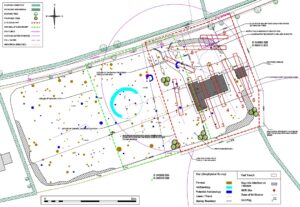
The subject site comprised a c. 0.3-hectare agricultural greenfield plot which falls within the Zone of Notification (Zone ID: R140044) for a ring-ditch (KK010-160—-). Additionally the Zone of Notification for an enclosure (KK010-159—-), recorded c. 50m to the southeast of the subject site, extends within its south-eastern boundaries.
A geophysical survey (Survey licence no. 25R0093) of the site was carried out by Shanarc Archaeology Ltd. in February 2025 prior to the test-excavations. The survey identified multiple potential archaeological anomalies, and ring-ditch (KK010-160—-) was identified in an area that would be directly impacted by the proposed development. Due to the findings of the geophysical survey, the location of the proposed development site was moved c. 35m further to the east, into an area still covered by the geophysical survey but avoiding the ring-ditch as well as the majority of the potential archaeological anomalies identified during the geophysical survey.
Testing comprised the excavation of nine targeted test-trenches. The test-trenches were focused on the footprint of the proposed development as well as on the anomalies identified as potential archaeology in the geophysical survey data which fell within the wider development area.
The excavated test-trenches were 1.9m in width and varied in length from 15–30m, with a maximum depth of 0.2–0.4m. The stratigraphy was relatively consistent throughout all excavated trenches, and comprised c. 0.1m of sod over c. 0.15–0.3m of mid-brown sandy silt topsoil, which in turn overlay natural subsoil, with occasional areas of gravel.
None of the anomalies identified as potential archaeology in the geophysical survey were found to be archaeological in nature and none were identifiable below topsoil level but were rather non-archaeological modern agricultural surface or near surface disturbance. The semi-circular anomaly shown by the geophysical survey in Trench 7 was definitively interpreted as surface disturbance from a cattle feed ring.
Aside from two sherds of modern pottery from the topsoil in Trench 3 which were not retained, there were no finds in any of the excavated trenches. No archaeological features or deposits were identified.