2025:525 - Letteragh (Carrownderry), Galway
County: Galway
Site name: Letteragh (Carrownderry)
Sites and Monuments Record No.: N/A
Licence number: 25E0391& 25R0182
Author: Fiona Rooney, Through Time Ltd
Author/Organisation Address: c/o Through Time Ltd, Killeenaran, Ballinderreen, Co. Galway
Site type: Burnt spread
Period/Dating: Undetermined
ITM: E 527315m, N 726446m
Latitude, Longitude (decimal degrees): 53.283343, -9.089996
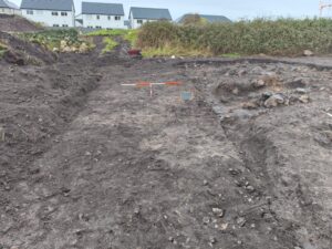
The burnt spread was located in the northeast of a development in the townland of Letteragh, Co. Galway, identified during the archaeological test trenching in May 2025. The field slopes gradually downwards to a waterlogged marshy area overgrown with rushes, a large boulder is located in the northwest. The archaeological excavation of the burnt spread was carried out over a period of 10 days.
Due to the waterlogged condition of the site in the east, the western part of the site was excavated first, measured 19.5m north-south by 13m and later extended east for 3m. Excavations revealed a spread of heat-shattered stones (C.2, 4 & 6) that overlay an area of burning (C.3) and the natural (C.7). The spread measured 15.64m by 10.59m and contained finds dating to the 19th century, fragments of glazed pottery, glass, a clay pipe bowl and stem. Excavations in the east of the site were prevented due to the waterlogged conditions. A slot trench was excavated and fragments of charcoal were recorded (C.6). No evidence of a trough was revealed during the course of the excavations.
Examination of the historic mapping indicates the field were divided from one large field in 1839 into 6 fields by 1892. The finds from the excavation date to this period and it is possible the burnt spread dates to this period. It is also possible the spread dates to an earlier period and was disturbed in antiquity. A sample of the charcoal is being prepared for identification by Dr Ellen O’Carroll and will be forwarded for radio carbon dating.
The archaeological monitoring of the mechanical excavations in the townland of Letteragh, Galway City, Co. Galway was carried out over a period of 4 days in January, 2026. The stratigraphy encountered was comprised of sod and topsoil overlying natural bedrock in the south and natural stoney gravel layers throughout. A deposit of peat was recorded in the northeast of the development and ranged in depth of 0.25-0.1.2m overlying the natural gravel and clay. No features and or finds of archaeological significance were encountered in the course of the monitoring.
The metal detection survey recorded a small amount of finds dating to the 19th and 20th century.