2025:226 - RATHGURREEN, Galway
County: Galway
Site name: RATHGURREEN
Sites and Monuments Record No.: GA095-009
Licence number: 25E0322
Author: Michelle Comber, Archaeology, University of Galway
Author/Organisation Address: Archaeology, University of Galway
Site type: Ringfort - rath
Period/Dating: Multi-period
ITM: E 537846m, N 720020m
Latitude, Longitude (decimal degrees): 53.226938, -8.930842
This excavation is part of the MAREE Archaeology Project, a multi-season research study with the overarching goal of exploring landscape use through time on the Maree peninsula, south Co. Galway. Rathgurreen, previously partially excavated by Michael Duignan in 1948 and 1949 (E945; Comber 2002), starts the excavation element of the project. Built on the western/inland side and highest land on the Maree peninsula, at approximately 30m O.D., the site affords excellent views of the surrounding countryside, especially to the north and west.
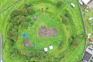
Rathgurreen is an impressive bivallate ringfort with a well-defined entrance to the northeast. The inner bank and ditch are much more substantial than the outer. The inner bank now averages 2m in height (above fort interior) while the base of the corresponding ditch is approximately 6m below the top of this bank. The ditch, in places, is a maximum of 9m in width across the top and 2.3m across the base. In comparison, the second bank is smaller, with just 3.7m between its top and the base of the inner ditch. This bank is subdivided along its circumference by a ‘hollow way’ or shallow ditch-like feature on its summit. The outer ditch measures approximately 4m in upper width and 1.5m at the base, and is a mere 0.7m below external ground level. The entrance gap in the inner bank is 2.6m in width while the causeway across the ditch is 4.4m wide. Internally, the site measures approximately 48m in diameter, 95m externally.
The 2025 excavation aimed to investigate part of the interior of the ringfort and part of the inner bank. The primary target (Cutting A) was a 10m x 20m cutting located near the center of the ringfort interior. It was designed to explore possible features identified in the magnetic and resistance geophysical surveys, in addition to targeting the part of a ringfort where most houses normally occur. This cutting also tested Duignan’s interpretations/techniques, deliberately overlapping the junction of his Trenches 1 and 2. Cutting B comprised a 2m-wide section through the inner bank on the north side of the ringfort. Duignan’s claim of finding pre-bank occupation material beneath this earthwork is key to understanding the construction sequence at the site.
Four broad phases have been identified. Due to repeated clearances and disturbance of the site interior, it was difficult to assign definite phases to many features during excavation. Until radiocarbon dates are obtained, they are simply described as pre-ringfort, ringfort era (in two parts), and post-ringfort. It is provisionally suggested that these phases date to late prehistory, the early medieval period, (perhaps into medieval?), and the early modern/modern era. The aforementioned radiocarbon dating will facilitate refinement of this stratigraphic sequence.
PHASE 1 Pre-Ringfort: The first phase of monument activity at the site is represented by the outer bank and its external ditch, with an overall external diameter of approximately 95m. Later clearance resulted in only patchy survival of Phase 1 activity layers, but such material was found beneath the ringfort’s inner bank, clearly pre-dating its construction. In the interior of the site, a stone spread and two pits are associated with this phase. Those pits produced prehistoric pot sherds and glass beads possibly of Iron Age date.
PHASE 2 Ringfort I: The impressive inner ditch and bank were added, transforming the earlier enclosure into a high-status ringfort. Earlier material was cleared from the interior and a new circular structure, metal workshop, and central post-built structure added. Finds such as pottery from northern France (‘E-ware’) and amber beads reflect the expected early medieval date of this phase.
PHASE 3 Ringfort II: The interior of the site was cleared once again. The earlier structures were removed and a stone-lined kiln was added in a relatively central location within the ringfort, suggesting a more agricultural focus during this phase. Dating awaits C14 results.
PHASE 4 Post-Ringfort: In early modern/modern times the site was cleared again and used to feed/house livestock.