
2025:726 - 146–156 Harold’s Cross Road, Dublin 6W, Dublin
County: Dublin
Site name: 146–156 Harold’s Cross Road, Dublin 6W
Sites and Monuments Record No.: DU018-050--- Settlement
Licence number: 24E0596 ext.
Author: Steve Hickey, c/o AMS
Author/Organisation Address: Fahy's Road, Kilrush, Co. Clare
Site type: House foundations - Late 17th-19th century
Period/Dating: Post Medieval (AD 1600-AD 1750)
ITM: E 714555m, N 731825m
Latitude, Longitude (decimal degrees): 53.324273, -6.280427
Archaeological excavation works were carried out at Nos 146–156 Harold’s Cross Road, Dublin 6W. The excavation works were conducted between November 2024 and April 2025. Works comprised the ground reduction and preservation by record across the site to formation level (c.0.8m below ground level).
The excavation works were conducted following recommendations within an Archaeological Testing Report and Impact Assessment (Hickey & Mac Gowan 2024) for the site, which was itself informed by a two-phased programme (Phases 1 and 2) of archaeological test-trenching (carried out in June and September 2024) as well as monitoring of demolition works and site investigation works. It was recommended that “preservation by record” works be carried out on the exposed archaeological remains to development formation level across the site.
Excavation works identified, investigated and recorded the foundational remains and original built fabric of previously demolished buildings which once occupied the five plots within the site (Plot Nos 146–156). Works revealed cobbled surfaces and masonry foundations of buildings dating to the eighteenth century (two Dutch Billies with a shared central passageway in Plot Nos 148 and 150 and a chapel in Plot No. 156) and nineteenth century (the basement of a terrace house in Plot No. 146 and a possible school building in Plot No. 156). The earliest structural remains within the site were the masonry foundations of a rectangular building (Structure 1) which underlay and pre-date the Dutch Billy foundations at Plot Nos 148 and 150. Structure 1 would date to the late-seventeenth/early eighteenth century.
The site contains a Protected Structure, No. 152 Harolds Cross Road, listed on the Record of Protected Structures (RPS No. 8899) as an “early eighteenth century, three-storey” building dating to c.1740. This building was subject to additional conservation planning conditions which aimed to ensure it was protected and preserved during the proposed construction works and incorporated into the final development.
Following archaeological excavation above formation level, the archaeological material (exposed courses of eighteenth-/nineteenth-century walls, cobbled surfaces, etc.) was removed under a monitoring brief. Any archaeological remains beneath the formation level have been preserved in situ. In circumstances where walls dating to the eighteenth century and earlier were located in the path of the proposed piling and ground beam layout, they were excavated to their base; this included circumstances where the base of the wall extended beneath the proposed formation level.
Archaeological excavation to formation level of the proposed development and subsequent monitoring of the piling programme was carried out and the development area is considered archaeologically resolved.
The works uncovered a number of post-medieval finds (i.e glass, ceramic, and clay tobacco pipe) which were subject to specialist analysis. The material dated from the late seventeenth to the early twentieth century.
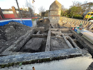
Exposed foundations.