2025:521 - Garda Mounted Unit Arena, Phoenix Park, Castleknock, Dublin 8, Dublin
County: Dublin
Site name: Garda Mounted Unit Arena, Phoenix Park, Castleknock, Dublin 8
Sites and Monuments Record No.: DU018-007001--- Deerpark
Licence number: 25E0581
Author: Alva Mac Gowan / Archaeology Plan
Author/Organisation Address: 129 North Strand Road, Dublin 3 D03 W8C1
Site type: Greenfield
Period/Dating: Modern (AD 1750-AD 2000)
ITM: E 690847m, N 761137m
Latitude, Longitude (decimal degrees): 53.592215, -6.627714
Archaeological monitoring took place on 13 August 2025 of groundworks relating to a safety upgrade and routine maintenance to the Garda Mounted Unit Arena and Lunging Ring at the North Road, Phoenix Park and within the curtilage of Áras an Uachtaráin.
A previous riding arena and lunging ring had been in place, to a depth of 0.4cm below ground level (BGL), the total area of the riding arena was increased from 15m to 20m. The original arena was sloping and required levelling; this meant that the only excavation to take place was in the north-west corner, where the ground was higher than the rest of the site. This was for drainage channels. The depth of the drainage channels varied from 0-0.75m BGL depending on the ground level; the other arena sections were levelled off and drainage pipes were inserted into a subsurface layer of angular stones below the arena surface.
The general stratigraphy consisted of green pasture topsoil measuring approximately 0.1m in depth. Appearing at 0.1m below current ground level (C3) was a compact dark greyish-brown clay with a scattering of fragmented 19th-century historical refuse consisting of clay pipe fragments, 19th-century ceramics, animal bones and oyster shell fragments. This layer could be interpreted the remnants an old plough soil, surviving because this field has been undeveloped or affected by intensive farming. The natural subsoil appeared at approximately 0.34m BGL; this consisted of a homogenous compact sticky yellow clay. One of the reasons for the drainage channels to be inserted below the lunging area and riding arena was because of the site’s tendency to become waterlogged. The high concentration of clay in the site’s subsoil would explain the poor drainage.
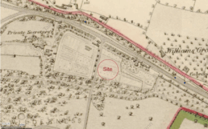
The presence of fragments of 19th-century refuse in C3 could easily be attributed to the age-old practice of disposing refuse from local dwellings in nearby fields. The material is then churned up during ploughing causing a scattering of fragmented historical refuse such as pieces of glass, ceramics and clay pipes together with food waste like shell and animal bone. This context could be related to cultivation at the site in the 19th century. The First Edition 6 inch OS Map that was surveyed in 1836 depicts the site as a patchwork of allotments used for cultivation.
No archaeology was found.