2025:384 - SWORDS: Ward River Regional Park, Brackenstown, Dublin
County: Dublin
Site name: SWORDS: Ward River Regional Park, Brackenstown
Sites and Monuments Record No.: N/A
Licence number: 23E0880
Author: Steven McGlade, Archaeology Plan
Author/Organisation Address: 129 North Strand Road, Dublin 3, D03W8C1
Site type: Excavation - miscellaneous
Period/Dating: Multi-period
ITM: E 716076m, N 746741m
Latitude, Longitude (decimal degrees): 53.457927, -6.252125
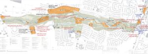
Fingal County Council are in the process of carrying out a number of upgrading works throughout Ward River Regional Park. A number of these works took place in 2025 and required archaeological investigation. None of the works in 2025 were in close proximity to the Recorded Monuments in the park. Brackenstown Mill and associated features, and Brackenstown walled gardens are both listed by Fingal County Council as Protected Structures.
Historic structures conservation works
A programme of emergency repair works was undertaken on a number of structures within the Ward River valley. The works focused on the early eighteenth-century cascades, constructed by Robert Molesworth. The cascades are associated with a basin, originally octagonal in layout, and a bridge to the east. The cascades structure and the bridge formed two of the sides of the basin. The monitoring uncovered an additional culverted drain on the northern side of the cascades. This was incorporated into the cascades structure, and was a feature of the original early eighteenth-century structure. A short section of stone steps to the northwest of the cascades, associated with the masonry retaining wall along the north side of the valley, was a contemporary structure conserved during the works. These originally led to a summerhouse located on the sloping valley side, which no longer survives. During the works a brick-lined well was uncovered to the south of the cascades. This was depicted on cartographic sources, but had not been identified previously due to the dense undergrowth in this area. The well may also date to the early eighteenth century as Molesworth’s letters refer to numerous fountains, springs and water features along the base of the valley in Brackenstown forming part of his gardens.
The remaining structures included in the conservation works related to later activity associated with Brackenstown Mill, which was constructed to the north of the cascades by the nineteenth century. The cascades, basin and east bridge were altered during the lifetime of the mill, and evidence for some of these alterations was identified during the works.
The construction of the mill involved the creation of a new channel for the river running along the southern side of the pond west of the cascades and the formation of a millpond directly west of the cascades. The bridge and weir at the east end of the channel as it flowed into the millpond were both conserved during the works. The bridge in particular was in need of repair, with significant undercutting evident. During the works a second weir was identified directly beneath the bridge.
A culvert and sluice gate to the south of the cascades, conserved during the recent works, would have aided the control of water levels in the millpond, and is a component of the early nineteenth-century activity at Brackenstown.
At either end of the Great Pond, constructed by Molesworth in 1709 and now known as Usher’s Lake, sluice gates were investigated. The sluice gate to the west was of concrete construction with no visible indication of earlier fabric. As the water supply for the lake was originally via a millrace and separate from the river, this was clearly a later addition. The sluice gate to the east was associated with the masonry remains of a boathouse, which was depicted on nineteenth-century mapping. It was unclear whether this structure was contemporary with the original creation of the pond, though a sluice gate in this location would have been required. The eastern outflow of the structure would have needed to be altered or completely rebuilt when the millpond was created, so it is equally possible the structure is contemporary with the mill phase. No conservation works were undertaken on either sluice gate. Both are no longer functional.
During the conservation works to the cascades a fish bypass channel was constructed to the north. This runs through the site of the mill and a number of walls and surfaces associated with the building were identified and surveyed during the monitoring of these works.
Brackenstown walled gardens
Additional investigations were carried out within the former walled gardens of Brackenstown House. The works focussed on four garden features that are to be conserved and retained as components of the gardens when they are brought into the lands of the park. The structures include a nineteenth-century pit-house – a subterranean greenhouse, with two distinct phases of use, which was uncovered in the southern walled garden. The pit-house was depicted on cartographic sources and had been identified during the previous testing programme, though its preservation was unclear. The works fully uncovered the remains of the pit-house, which was in better condition than previously expected. The initial phase involved the beds being heated by manure deposited within a surrounding trench. This system was upgraded with the inclusion of a furnace at a later stage.
The second structure was an early 20th-century octagonal conservatory at the west end of the northern walled garden. This was partly exposed during the previous works on the site. The remainder of the structure and the associated boiler house to the rear was uncovered this year.
The third structure was an early 20th-century vinery at the northern end of the northern walled garden. Part of this was exposed during last year, with additional elements identified during the testing programme. The works this year fully uncovered the structure and identified numerous additional elements. The remains of a masonry wall associated with an earlier greenhouse structure were also identified during the works. The earlier structure was first depicted cartographically in the 1830s, though it may be contemporary with the construction of the walled garden in the late eighteenth century.
The fourth structure was a potting shed, which was first depicted cartographically in the 1830s. It was later replaced by a greenhouse by the early twentieth century, the remains of which were also identified.
Northern playing fields
A programme of archaeological test-trenching was undertaken in September 2025 in the northern portion of Ward River Regional Park in advance of proposed upgrading works within the park. The testing assessed a number of geophysical anomalies that were identified in a recent survey (24R0587). The programme was designed to test a number of these anomalies while leaving the existing playing fields available for use at this stage. The testing demonstrated that a significant wedge of imported soil was present at the southern end of the area, which was used to level up the ground prior to the laying out of the existing playing fields. The majority of the geophysical anomalies were found to be non-archaeological.
The testing identified a probable cremation pit and a metalled surface. The programme also identified a number of linear ditches with animal bone and shell inclusions, which may be archaeological or agricultural.