2025:330 - DUBLIN: Dartry Park, Bankside Cottages, Bankside & Clonskeagh Road, Dublin
County: Dublin
Site name: DUBLIN: Dartry Park, Bankside Cottages, Bankside & Clonskeagh Road
Sites and Monuments Record No.: DU022-096002, DU022-004002/003/006, DU022-004001, DU022-090
Licence number: 25E0726
Author: Gill McLoughlin, c/o Courtney Deery Heritage Consultancy
Author/Organisation Address: Unit 5B, Block F, Nutgrove Office Park, Rathfarnham, Dublin 14
Site type: Watercourse and Building
Period/Dating: Undetermined
ITM: E 716747m, N 730229m
Latitude, Longitude (decimal degrees): 53.309457, -6.248127
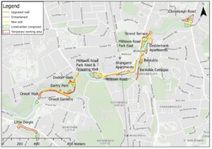
Pre-planning archaeological testing was carried out in order to inform an EIAR relating to the Dodder Flood Alleviation Scheme (FAS) which it is proposed to construct along the banks of the River Dodder between Orwell Bridge in Rathgar and Clonskeagh Bridge.
Four locations were selected for archaeological testing, at Dartry Park, Bankside Cottages, Bankside and Clonskeagh Road targeting areas of proposed embankments and temporary construction compounds.
Trenches 3 and 4 were excavated at Bankside Cottages, within the Zone of Notification (ZoN) for Packhorse Bridge (DU022-004001) and Mills (DU022-004002/003/006). Stone walls were uncovered as little as 0.1m below the ground surface, immediately beneath the sod. In Trench 4 the walls were oriented north-northeast/south-southwest and in Trench 3 a single wall was oriented west-northwest/east-southeast and in both cases they appear to align with structures depicted on the first edition 6-inch OS mapping and/or the 25-inch OS mapping, making a 19th-century date for the walls likely, although there is also the potential for there to be remains of mill buildings in this location.
Trenches 5 and 6 were excavated at Bankside, in the vicinity of a section of millrace and a footbridge over it. A continuation of the undated millrace wall was uncovered in Trench 6 at 0.55m beneath the present ground surface and in Trench 5 there was no evidence for the footbridge over the millrace extending further sub-surface, although a granite step at the edge of the bridge was present immediately below the ground surface.
Trench 7 was excavated at Clonskeagh Bridge within the ZoN for an earlier bridge. No trace of the former bridge structure (DU022-090) was found, although hand-cut paving cobbles were found dispersed throughout the mixed made ground in the trench which was tested to a depth of 1m. The cobbles were not in situ but could represent paving stones from a former bridge, such as those in situ on Packhorse Bridge to the southwest.
Trench 2 was excavated in Dartry Park within the ZoN for a former millpond (DU022-096002). There were no archaeological deposits, soils or artefacts uncovered in Trench 2 in Dartry Park and no indication that the millpond extended to this location.