2025:524 - Cappagh, Kinsale, Cork
County: Cork
Site name: Cappagh, Kinsale
Sites and Monuments Record No.: CO112-090----
Licence number: 25E0242
Author: David Murphy
Author/Organisation Address: 3a Westpoint Trade Centre, Link Road, Ballincollig, Cork
Site type: 17th-century military fortification
Period/Dating: Post Medieval (AD 1600-AD 1750)
ITM: E 562905m, N 550610m
Latitude, Longitude (decimal degrees): 51.706645, -8.536727
A programme of archaeological mitigation was undertaken at a permitted residential development site at Cappagh, Kinsale, County Cork during 2025. A previous testing programme (22E0728) had indicated the presence of a linear ditch feature within the site, however, on further investigation in March 2025, it became apparent that a more substantial and significant archaeological site lay unrecorded within the development site.
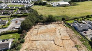
A subsequent supplementary testing programme, carried out under Excavation Licence 25E0242, confirmed beyond doubt the presence of a military entrenchment or fortification defined by an enclosing ditch laid out in a classical post-medieval military style with flanking corner projections/bastion-type features. It was possible to determine that the maximum internal dimensions of the entrenchment across its northern and western portions were approximately 36m north-north-west/south-south-east by 36m. The military regularity of the feature was further reflected with its internal dimensions, excluding any flanking corner projections/bastions, measuring approximately 26m north-north-west/south-south-east by 26m. The discovery appears to be the correct location of military camp (CO112-090—-), which the ASI record to be located 125m to the northwest of this location. This was one of a number fortifications which Crown forces established around Kinsale during the siege of the town between October and December 1601.
Following consultation and approval of the relevant authorities, a programme of excavation was undertaken at the site between July and September 2025. The excavation revealed that the fortification was laid out to a predetermined design and was defined by an earth-cut enclosing ditch which, in general, measured between 2.5m and 2.7m in width and 0.4m to 0.6m deep (as measured from upper subsoil level), increasing to 3.95m wide and 0.9m deep at the salient angles of the bastions. The fortification can be best described as ‘shuriken-shaped’ or of the shape of a four-pointed star with one flank and one face on each of the angled or demi-bastions. The bastions were located in the north-west, south-west, south-east and north-east corners of the fort. The intervening straight sections of ditch linking the angled bastions were orientated north-northwest to south-southeast and east-northeast to west-southwest.
A subsequent programme of archaeological monitoring was undertaken during the stripping of remaining topsoil at the development site between 8 and 13 October 2025. No additional features of archaeological interest were revealed during the monitoring programme.
Further detail on the excavation will be provided following the completion of the ongoing post-excavation analysis.