2025:388 - CARRIGDOWNANE UPPER, Rockmills, Cork
County: Cork
Site name: CARRIGDOWNANE UPPER, Rockmills
Sites and Monuments Record No.: N/A
Licence number: 25E0821
Author: Seán Shanahan; Shanarc Archaeology Ltd.
Author/Organisation Address: Unit 39A, Hebron Business Park, Hebron Road, Kilkenny
Site type: Pit and Kiln
Period/Dating: Undetermined
ITM: E 571790m, N 606608m
Latitude, Longitude (decimal degrees): 52.210518, -8.412771
Archaeological text excavations were carried out on 9 September 2025, in relation to the proposed extension of Rockmills Limestone Quarry, at Carrigdownane Upper, Rockmills, Co. Cork.
Prior to the test excavations, the site was subjected to a geophysical survey under survey licence no. 25R0301.
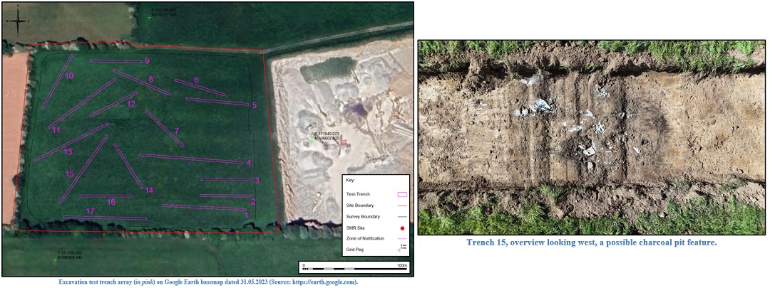
A total of 17 trenches (labelled 1–17) were excavated using a mechanical digger with a flat grading bucket, targeting anomalies identified as potential archaeology in the geophysical survey.
The excavated trenches were c. 2m in width and varied in length from 50–100m. Trenches were excavated to a maximum depth of c. 0.22–0.35m. The general stratigraphy comprised c. 0.08m of sod, overlying topsoil comprising a moderately compact, mid-brown sandy silt with a frequent amount of small-sized sub-rounded stones. The underlying subsoil comprised a light brown, moderately compact, sandy silt with a moderate amount of small-sized sub-rounded stones; there was occasional evidence of modern agricultural activity in the way of plough marks and linear drains.
Trench 15 was the only trench to produce any evidence of archaeological activity. Towards the south-west end of the cutting, approx. 15m from the end, an isolated spread of charcoal material adjacent to a localised outcrop of limestone was noted. The feature was circular in plan, measuring 2m in diameter, and was interpreted as representing a pit or possible kiln.