2025:362 - CARRIGROHANE & INCHIGAGGIN, Cork
County: Cork
Site name: CARRIGROHANE & INCHIGAGGIN
Sites and Monuments Record No.: N/A
Licence number: 25E0662
Author: Gill McLoughlin, c/o Courtney Deery Heritage Consultancy
Author/Organisation Address: Unit 5B, Block F, Nutgrove Office Park, Rathfarnham, Dublin 14
Site type: House - 18th/19th century
Period/Dating: Modern (AD 1750-AD 2000)
ITM: E 562604m, N 571429m
Latitude, Longitude (decimal degrees): 51.893765, -8.543327
Archaeological testing was carried out pre-planning on behalf of the National Transport Agency, relating to a proposed link road connecting Model Farm Road to the N22 National Road as part of the Cork City South West Sustainable Transport Corridors Scheme.
The archaeological testing followed a geophysical survey and was carried out to inform the Archaeology and Cultural Heritage chapter of an Environmental Impact Assessment Report (EIAR).
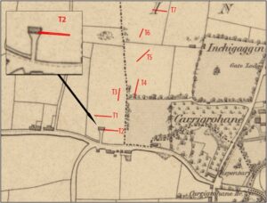
The testing took place over three days from 29 September 2025. For the most part, the geophysical survey proved to be quite accurate and the targeted geophysical anomalies proved to either be agricultural/drainage features or variations in the natural subsoil. In the west end of the southernmost trench (Trench 2), a large deposit of early modern material representing a demolished house was present. This material related to a late 18th or early 19th-century house which was depicted on the first edition OS map of 1842.
.