2025:329 - Ballyharoon, Cork
County: Cork
Site name: Ballyharoon
Sites and Monuments Record No.: CO063-087002-
Licence number: 25E0837
Author: Aidan Harte
Author/Organisation Address: Munster Archaeology, Inverin, Co. Galway
Site type: No archaeological significance
Period/Dating: N/A
ITM: E 570953m, N 575410m
Latitude, Longitude (decimal degrees): 51.930047, -8.422364
Archaeological test trenching was undertaken at Ballyharoon, Co. Cork, on the 25th September 2025. This was south of recorded monuments, Church and Graveyard (SMR No.CO063-087001- and CO063- 087002-) and formed part of an archaeological assessment for the development area to be used as an extension to an existing modern cemetery immediately to the west. While in the townland of Ballyharoon, this is commonly referred to as Rathcooney Cemetery.
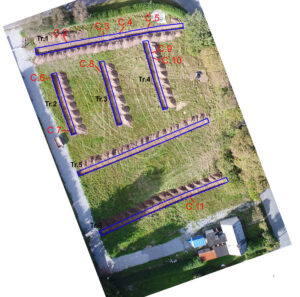
Test trenching was carried out under excavation licence 25E0837 and consisted of six trenches laid
out to optimise assessment of the proposed cemetery plot layout. It also intensively focused on the
area at the north of the field which was within the constraint zone surrounding the church and
graveyard. A total of 190m of linear trench was investigated.
In all, archaeological test trenches identified ten features. Two of these related to trial holes excavated in early 2025 (in trenches 1 and 6). All other features were confined to the northern half of the site, and with two exceptions, appeared as linear drains or furrows. These were either orientated east-west (in trenches 2, 3 and 4) or north-south (in trench 1) and are consistent with agricultural practices. No artefacts were found associated with any of these features. The north-south alignment of angular stone (almost central in trench 1) is very likely a basal course of a drystone wall, i.e. field-boundary, but nothing could indicate its form or date of origin. Similarly, the small dark deposit (trench 4) was probable the result of burning and fertilising of the soil and cannot be considered archaeologically significant. These features were all between 0.28m – 0.5m below the present surface, i.e. the thickness of topsoil here.
Nothing of archaeological significance was identified.