2024:297 - BRUSSELSTOWN RING, Spinans Middle, Brusselstown and Castlequarter, Wicklow
County: Wicklow
Site name: BRUSSELSTOWN RING, Spinans Middle, Brusselstown and Castlequarter
Sites and Monuments Record No.: N/A
Licence number: 24E0897
Author: Dirk Brandherm
Author/Organisation Address: Queen’s University Belfast
Site type: Hut site
Period/Dating: Prehistoric (12700 BC-AD 400)
ITM: E 692959m, N 691154m
Latitude, Longitude (decimal degrees): 52.963092, -6.616282
Archaeological test excavations were undertaken from 26 August–4 September 2024 at the summit and southeast side of the Spinan’s Hill Complex, known as Brusselstown Ring Hillfort in the townlands of Spinans Middle, Brusselstown and Castlequarter in Co. Wicklow. The site is located on a southwest spur of the Wicklow Mountains. GPS and photogrammetry by James O’Driscoll in 2017 identified surface anomalies that provide possible evidence of 600-plus prehistoric dwellings within the uppermost and middle enclosing elements of the site.
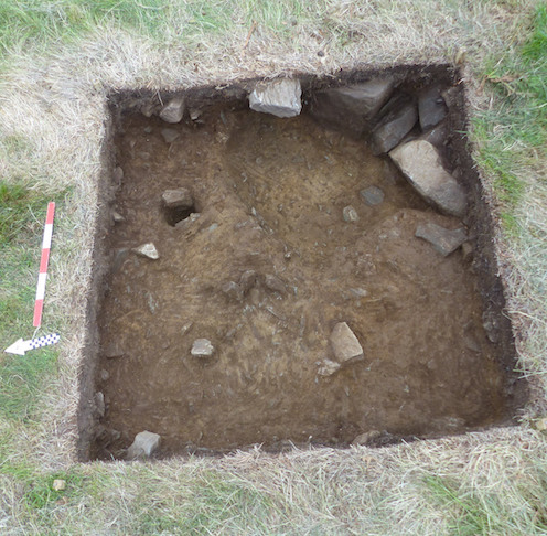
Two test trenches (T1 and T2) were located on micro topographical anomalies identified by the photogrammetry survey. T1 and T2, each measuring 1.5m × 1.5m, were opened. T1 was located on ITM 692903.35, 691179.45 and T2 was located on ITM 693230.37, 691174.04. Evidence produced from both trenches is consistent with the presence of anthropogenic prehistoric structures.
T1 produced evidence of scattered charcoal through Contexts 2 and 3. Context 4 produced a 0.06m deep, charcoal-rich layer on top of a cobble base. Context 4 extended across the entirety of the trench and appears to be consistent with a burning event. A charcoal-rich streak ran south-east/north-west below Context 4 and was embedded into the geological subsoil below. A single stake-hole was visible within the profile along the north-west edge of T1, having been driven into the subsoil and infilled with material from Context 4. Two small stones of undetermined origin, one quartz pebble and one possible clay fragment, were recovered from T1. Charcoal samples were taken at all levels for radiocarbon dating.
T2 produced evidence of scattered charcoal below the topsoil layers (Contexts 0 and 1) within Context 2. A sloping pit measuring 0.7m (width) × 0.37m (breath) × 0.47m (depth) was identified within the southeast corner of T2. The pit contained two layers (Context 4 and 5) of soil infill with high charcoal concentrations. Context 4 contained larger pieces of charcoal and small stones throughout. Context 5 contained charcoal and small to medium stones. A post-hole was identified along the north-east limit of the pit and contained fill consistent with material matching the infill from Context 4. At least one other cluster of three upright stones was identified along the curve of the pit, which could have been post-/stake-holes, but no deeper layer was identified below Context 2 at the location. One piece of worked flint was recovered from Context 2. Charcoal samples were taken from all contexts for radiocarbon dating.

Test Trench T2
