2024:705 - BALLYNABRIGADANE & BALLYLUCAS, Ballymurn, Wexford
County: Wexford
Site name: BALLYNABRIGADANE & BALLYLUCAS, Ballymurn
Sites and Monuments Record No.: N/A
Licence number: 24E0699
Author: Michael Greiner & Seán Shanahan; Shanarc Archaeology Ltd.
Author/Organisation Address: Unit 39a, Hebron Business Park, Hebron Road, Kilkenny
Site type: Kiln, Hearth, Pit and Enclosure
Period/Dating: Undetermined
ITM: E 705025m, N 633357m
Latitude, Longitude (decimal degrees): 52.441583, -6.455193
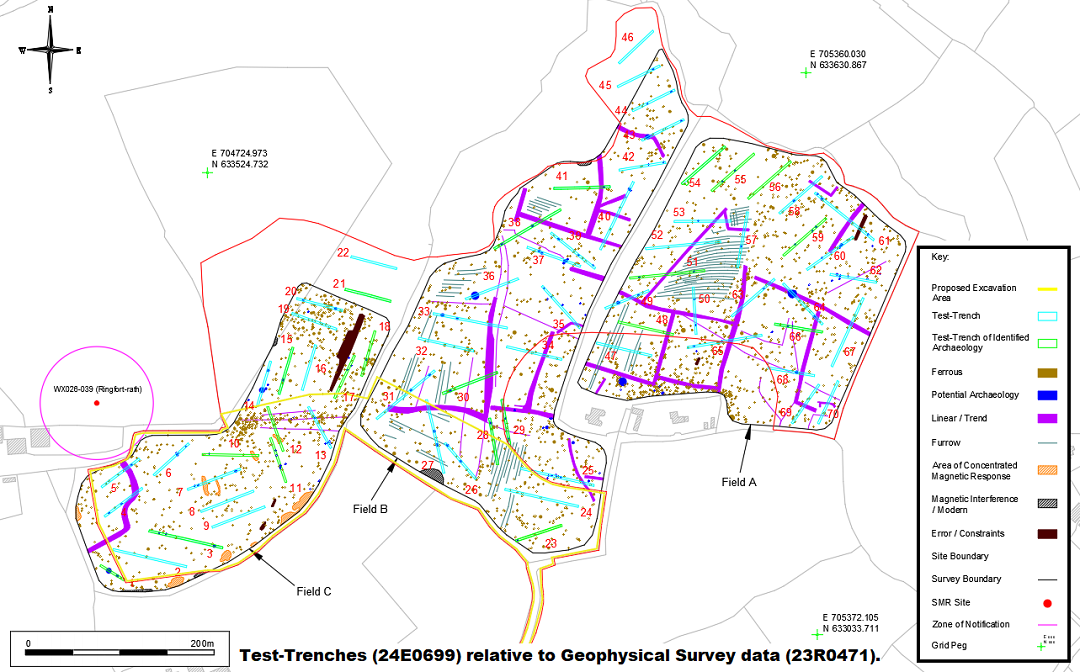
A programme of archaeological test-trenching was carried out between 9–14 August 2024, in relation the proposed expansion of a quarry/sandpit plus ancillary works on a c. 22-hectare greenfield site located in Ballynabrigadane and Ballylucas townlands, at Ballymurn, Co. Wexford.
There are no recorded archaeological sites within the proposed development area. A single recorded monument comprising a ringfort/rath (WX026-039) is located within close proximity of the site; this ringfort is located c. 60m to the west of the proposed development area, and its associated Zone of Notification (Zone ID: R146135) abuts the proposed development area’s western boundary.
The proposed development site was previously the subject of an Archaeological and Cultural Heritage assessment carried out by Shanarc Archaeology Ltd. (Reilly, 2024) as part of an Environmental Impact Assessment Report (EIAR), as well as a geophysical survey (Prospection Licence No. 23R0471) which was also carried out by Shanarc Archaeology Ltd. (Greiner & Shanahan, 2023). The geophysical survey identified evidence of extensive historic field systems, as well as numerous potential archaeological anomalies.
The purpose of the archaeological test-excavations was to identify any potential subsurface archaeological finds, features or deposits within the proposed development site, with particular emphasis on those anomalies identified as potential archaeology in the geophysical survey report and/or as areas of archaeological potential in the EIAR report.
Testing comprised the excavation of seventy test-trenches across the proposed development area. Test-trenches were 2m wide, 30–80m in length, and had maximum depths varying from 0.2–0.8m.
The stratigraphy within the test-trenches was relatively consistent across the site: gray-brown silty sandy topsoil was overlying natural subsoil. The underlying natural predominantly comprised gray-brown or yellow-gray sandy clay with areas of sand and occasional areas of gravel.
Twenty-two of the test-trenches (1, 3, 10, 11, 12, 15, 17, 18, 21, 23, 28, 29, 30, 38, 41, 48, 51, 54, 55, 56, 59, & 66) produced clear evidence of archaeological activity, primarily in the form of linear features, pits and possible hearths and/or kilns, and numerous other trenches produced linear features which were identified as furrows, former field boundaries and drains.
No archaeological objects/finds were identified in any of the excavated test-trenches.