2024:537 - BALLYKELLY, Ballymurn, Wexford
County: Wexford
Site name: BALLYKELLY, Ballymurn
Sites and Monuments Record No.: WX026-039
Licence number: 23E0089
Author: Michael Greiner & Graeme Laidlaw; Shanarc Archaeology Ltd.
Author/Organisation Address: Unit 39a, Hebron Business Park, Hebron Road, Kilkenny
Site type: No archaeology found
Period/Dating: N/A
ITM: E 704592m, N 633280m
Latitude, Longitude (decimal degrees): 52.440974, -6.461584
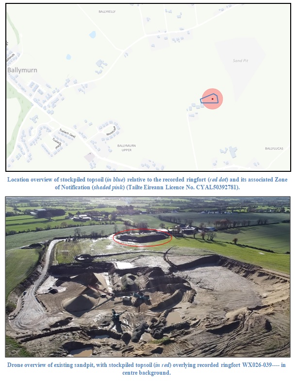
An existing planning permission for a quarry/sandpit required that a qualified archaeologist monitor all groundworks associated with the removal of topsoil from the footprint of the sandpit; however the permitted sandpit area was predominantly extracted, without having been archaeologically monitored, and the removed topsoil was stockpiled over the recorded location of a ringfort (WX026-039—-).
In 2023 Shanarc Archaeology Ltd. were contracted to monitor the removal of this stockpiled topsoil from within, and in the vicinity of the recorded ringfort (WX026-039—-). The material was being removed in order to reinstate an existing quarry/sandpit, located c. 200m north of the recorded monument.
Archaeological monitoring under licence 23E0089 was carried out between 8 May 2023 and 8 July 2024. Monitored works comprised the removal of the stockpiled topsoil mound in the location of the ringfort, and its removal to a new location on the southern edge of the existing quarry/sandpit.
The initial phases of monitored works took place on 8 May, from 16–18 October and on 29 November 2023. During the October/November period the weather was persistently wet, and metal road-plates had to be used to prevent the dump-trucks and tractors transporting the removed topsoil from damaging the ground around the ringfort. Eventually, due to the wet nature of the weather, the topsoil removal was postponed until the following summer.
The final phase of topsoil removal took place from 1–8 July 2024. Weather conditions at this time were sunny and dry, and the ground conditions in the surrounding field were firm and dry, meaning the previously used metal road-plates were no longer necessary.
The methodology comprised a mechanical excavator positioned directly on the stockpiled topsoil mound, which loaded a dump-truck and a tractor-trailer, which in turn ferried the removed topsoil to its new location at the edge of the existing sandpit. Here, it was formed into a berm by a second mechanical excavator.
The removed material generally comprised mid to light-brown sandy topsoil with occasional pockets of gray clay and occasional stones. The maximum height of the stockpiled topsoil mound prior to removal was c. 6–7m. The mound was reduced to a height of c. 0.5–0.8m and this remaining material was subsequently levelled across the area, serving both to fill in a number of natural undulations to aid the general drainage of the area, and to create a protective buffer over the area of the ringfort. The original sod, prior to the deposition of spoil, remained in situ.
No archaeological objects or materials were identified in the removed topsoil/spoil material.