2024:686 - CASTLEDALY: Boggagh (Conran), Westmeath
County: Westmeath
Site name: CASTLEDALY: Boggagh (Conran)
Sites and Monuments Record No.: WM036-014
Licence number: 24E0920
Author: Michael Greiner & Seán Shanahan; Shanarc Archaeology Ltd.
Author/Organisation Address: Unit 39A, Hebron Business Park, Hebron Road, Kilkenny
Site type: No archaeology found
Period/Dating: N/A
ITM: E 614977m, N 737327m
Latitude, Longitude (decimal degrees): 53.385898, -7.774867
Archaeological test-excavations were carried out on 28 August 2024, in relation to the proposed construction of a private residential dwelling on a 2.5-hectare agricultural greenfield site at Boggagh (Conran), Castledaly, Co. Westmeath.
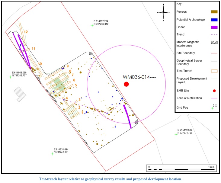
Ringfort (WM036-014—-) is located just outside the eastern boundary of the wider site, and the associated Zone of Notification (Zone ID: R142509) extends within the boundaries of the site.
Prior to the test-excavations, and in line with the planning conditions, a geophysical survey of the site was carried out under survey licence no. 24R0393, targeting the Zone of Notification associated with the ringfort as well as those areas of the site which where to be subjected to development. The geophysical survey identified a moderate number of anomalies which were interpreted as potential archaeology, primarily in the form of possible small to medium sized pit-type features, as well as several linear features and linear trends.
Test-excavation comprised the excavation of eleven test-trenches across the site. Twelve test-trenches had been proposed, however Trench 5 was not excavated on the day of testing, as it would have restricted access to the secondary field entrance at the west of the site which was required for use by the farmer on the day of testing. The test-trenches were generally targeted on the proposed development footprint, as well as on any potential archaeological anomalies or potential features of interest identified within this area during the preceding geophysical survey.
The stratigraphy of excavated material was generally consistent throughout all the excavated test-trenches. The sod layer measured c. 0.1m throughout all trenches, and the topsoil layer had an average depth of c. 0.15m, and comprised a moderately compact, mid-brown silty clay with a moderate amount of small and medium sized sub-rounded stones. The natural subsoil layer comprised a light brown, stony, compact, silty clay with pockets of coarse mid-grey gravel. Large sub-angular stones were met in the deposit throughout the assessment area.
No archaeological finds, features or deposits were identified in any of the excavated test-trenches.