2024:050 - CARRICK-ON-SUIR: Townparks, Tipperary
County: Tipperary
Site name: CARRICK-ON-SUIR: Townparks
Sites and Monuments Record No.: N/A
Licence number: 23E0807
Author: Thaddeus Breen & Graeme Laidlaw; Shanarc Archaeology Ltd.
Author/Organisation Address: Unit 39a, Hebron Business Park, Hebron Road, Kilkenny
Site type: Town
Period/Dating: Modern (AD 1750-AD 2000)
ITM: E 639676m, N 621876m
Latitude, Longitude (decimal degrees): 52.347042, -7.417669
Archaeological monitoring of works relating to the demolition of an existing former school building, and the construction of a new 2-storey school building and associated school grounds at Townparks, Carrick-on-Suir, Co. Tipperary was carried out between 2nd-17th January 2024.
The site comprises the buildings and grounds of the former Technical School in Carrick-on-Suir. Aside from the former school buildings, the site largely comprises a heavily overgrown garden area, and an overgrown orchard at the southeast of the site.
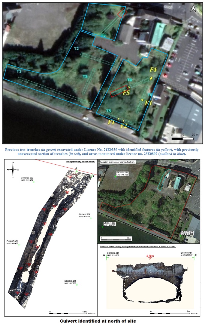
The site was previously subjected to an Archaeological and Cultural Heritage Assessment and subsequently to an Archaeological Assessment Report carried out by John Cronin & Associates, and involving archaeological test-excavation under Excavation Licence No. 21E0339, with an associated metal detection survey under Detection Licence No. 21R0131. The test-excavations undertaken by John Cronin & Associates in 2021 entailed the excavation of seven linear test trenches. In total, five late 19th- to early 20-th century features were identified in three of the excavated test trenches (Trenches 4, 5, and 6). These features comprised four walls/wall lines and one built garden feature. Manual cleaning revealed late 19th- to early 20th-century cultural material within the upper surfaces of these features, including clay pipe stems, pottery shreds and brick inputs. These archaeological assessments were undertaken in order to comply with a Further Information Request by Tipperary County Council, and Condition 4 of the subsequent grant of planning stipulated that development-related groundworks within the proposed development site be subjected to archaeological monitoring.
Archeologically monitored works under licence no. 23E807, consisted of monitoring topsoil removal and ground reductions associated with site clearance and demolition throughout the site, excluding those areas with upstanding buildings.
Previous Untested area:
The western end of previous Test-trench 5 was not originally tested due to the presence of mature apple trees in this area. It was decided that the apple trees were being retained in the final design and so the area was fenced off from construction traffic and no ground works will take place in this area. The northern end of previous Test-trench 7 was not originally tested due to the presence of a manhole. Topsoil removal was monitored here and the area in general was busy with services, septic tanks and concrete slabs/kerbs. A small test trench was excavated here, and a structure/rubble block was noted. It consisted of stone and brick bound with lime mortar.
East of Access road:
The area to the east of the access road was evidently a former garden area, containing a series of modern garden paths, formed with timber edge boards infilled with pea gravel and trace remains of a concrete layer overlying the pea gravel. The south-west of this area was particularly wet with up to 0.5m in depth of peaty garden topsoil present. For the most part the stripping only interfered with the uppermost 0.7m of the site. A small area of stone paving and lime mortar surface was exposed abutting the rubble stone boundary wall on the east boundary (2.74m north-south by 2.5m). This surface coincided with rendering on boundary wall, identifying it as a likely internal flooring of a former structure abutting the wall. The surface was overlain by silty sandy soil, containing fragments of lime mortar in turn partially overlain by a layer of yellow sand—likely to have been covered during the most recent use of the area as a garden.
West of access road:
No features of interest were observed in the area to the west of the access road. A dark brown humus-rich topsoil, c.0.15–0.2m deep, overlay mixed grey/brown silty clay containing scattered building rubble debris, including fragments of red and yellow brick, stone, slate, and fragments of lime mortar. Underlying this was a redeposited grey/brown silty clay also containing building debris.
Culvert:
A large culvert was identified at the north of the site. The culvert was subjected to a 3D photogrammetry laser scan prior to removal. The culvert aligns with a barrel-vault archway in the northern boundary wall. The archway is part of the northern boundary wall that covered the culvert to the south. The archway did not extend further to the south. South of the arch, the culvert ran for approximately 12m at an north-east/south-east orientation, before turning slightly and running at a north-north-east/south-south-west orientation for the 28m that it was exposed. The culvert did not meet up with the arch noted in the eastern boundary wall, beside the private house. The culvert, including its foundations, was removed. The culvert was built on a bright orange deposit that was occasionally seen throughout the site. This may be a natural deposit, or a redeposited natural. The culvert walls were approx. 0.7m wide and were a single course wide, with no obvious rubble core. There were some exceptionally large foundation stones but no stone floor. A black/dark brown matrix was briefly seen in the former footings. The culvert was filled with modern stone rubble and metal beams. A small area of blackened timbers was found to the east of the southern end of the culvert. They were of equal width. They were within the upper modern, disturbed area. The orange deposit was underneath. They may represent a previous attempt to provide a dry surface to walk on.

