2024:884 - Grangend Common, Meath
County: Meath
Site name: Grangend Common
Sites and Monuments Record No.: N/A
Licence number: 20E123
Author: Dominic Delany
Author/Organisation Address: Dominic Delany & Associates
Site type: Burnt spreads
Period/Dating: Prehistoric (12700 BC-AD 400)
ITM: E 697160m, N 752838m
Latitude, Longitude (decimal degrees): 53.516528, -6.534964
Archaeological monitoring of topsoil removal for Phases 1 and 2 of a residential development was carried out at Grangend Common, Co. Meath, in May and December 2024. The development site is located at the north-east edge of the town, immediately north of the zone of archaeological potential for Recorded Monument ME044-033, a medieval settlement at Dunshaughlin including the site of an early medieval church founded by St Seachnall. The land comprises approximately 8 hectares, and is divided by a small stream that extends north-south through the centre of the site. The general site topography consists of high ground in the west falling away to low-lying ground on the margins of the former Little Lagore Lough in the east. Previous archaeological testing at the site resulted in the discovery of a burnt spread on the east bank of the stream (2020:213). Phase 1 of the development consists of all lands on the west side of the stream.
The south and east parts of the Phase 1 site were topsoil-stripped in July 2023 (2023:897). The remaining lands on the west side of the stream were topsoil-stripped in May 2024. No archaeology was found during monitoring for the Phase 1 development.
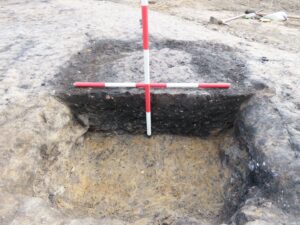
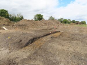
The burnt spread uncovered during previous testing on the east bank of the stream (2020:213) was excavated in August 2024. It consisted of a deposit of dark grey/black silty sand and gravel with frequent inclusions of small pieces of burnt stone. The spread was located on a slight northeast-southwest ridge. The deposit measured 10.5m by 8.5m in extent, and had an average thickness of just 0.2m. A trough (1.65m x 1.25m) was uncovered at the south-west edge of the spread. It was 0.35m deep and contained three distinct fills; a dark brown/black clayey silt upper fill, over slightly sandy/gritty black clayey silt, over light grey sand, grit and stone with some black clayey silt. No artefacts were found during excavation but a single sherd of Bronze Age pottery was found in the vicinity of the spread during testing in 2020 (2020:213).
Archaeological monitoring for Phase 2 of the development commenced in December 2024, when the north part of the large low-lying field on the east side of the stream was topsoil-stripped. Three areas of archaeological interest were identified during monitoring; two shallow deposits of burnt soil in the north-east extent of the field (AA1), a deposit of blackened soil in the central part of the field (AA2), and a burnt spread (c.5m x 3.8m) located c.10m from the previously-excavated burnt spread in the north-west part of the field (AA3). The three areas were covered with geotextile sheeting and sand, pending proposed further investigation and excavation in 2025.