
2024:878 - Bective Crossroads, Meath
County: Meath
Site name: Bective Crossroads
Sites and Monuments Record No.: vicinity of ME031-027---
Licence number: 24E1192
Author: Niall Roycroft
Author/Organisation Address: c/o Meath County Council, Buvinda House, Dublin Road, Navan, Co Meath. C15 Y291.
Site type: Vicinity of 16th-17th-century building
Period/Dating: Modern (AD 1750-AD 2000)
ITM: E 686285m, N 759695m
Latitude, Longitude (decimal degrees): 53.580030, -6.697003
Bective
Meath County Council completed a junction realignment at Bective Cross, with an overall project area of 650 sq. m. The works are in proximity to ME031-027: a ‘wall for a 16th-17th C building’ noted in JRSAI 1916, p.57, of which there are no visible remains. Monitoring took placed between 6th November 2024 and 16th January 2025. Site levels were from 52.75m OD – 55m OD.
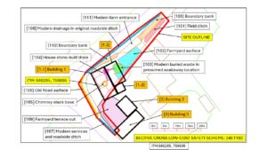
The site was occupied by a domestic farmhouse (Building 1) that previously doubled as a local shop with two lean-to outbuildings. Two other buildings were recorded, demolished and replaced as part of landowner accommodation outside the area of the junction works. Building 1 had been previously converted into a cow shed with a corrugated iron roof. However, the red brick surrounds to the windows survived to be recorded, as did the main masonry porch that incorporated an OS benchmark. An OS benchmark stone in the porch wall was retained and reset in the new farmyard gate pier. The base of Building 1 central chimney was noted and a stone drain led from the house to a (dug-out and replaced) soakaway.
Outbuilding Building 2 survived with a slate roof with walls of a combination of masonry in the lower sections and clay wall upper sections. Outbuilding Building 3 had partially collapsed and only two walls remained to any height. These walls had the same masonry lower sections and clay upper parts (clay tobacco pipe stem fragment noted in the clay) as in Building 2.
No remains relating to anything earlier than the post-medieval farm were found.
Natural ground at the west end of the site consisted of banded sandy to stoney light grey/yellow/brown post-glacial deposits forming the knoll on which Bective Cross is built. The top of this knoll is the location of Bective Fair Green and is the possible location for the 16th-17th-century house, ME031-027, which was presumably located to overlook the junction, the River Boyne Crossing and the landscape.
The farmyard was terraced into the rising ground and the gravel road for the north-south-running L4010 Bective to Kilmessan Road was recorded in section. All finds were 19th-20th century and consisted of standard, domestic pottery (tableware and storage ware), metalwork (including parts of a donkey harness, spades etc.), machine-made glass bottles and plastics. These were photographed and recorded on site but not retained.
On the south-west side of the junction, additional ducting trenches totalling 25m x 0.6m wide x 0.75m deep were dug in February 2025. The works were very close to ME031-027: the ‘wall for a 16th-17th C building’. A piece of masonry wall 0.45m wide x 0.3m high, oriented north-west/south-west and bonded in grey mortar was recorded in the ducting trench at ITM 686260, 759679. This wall appeared to be part of a boundary wall to a yard seen on the 25-inch map, in which the landowner recalled seeing a tiring platform belonging to blacksmith John/Jack Toomey, who worked here in the mid-20th century.