2024:191 - OLDCASTLE: Fair Green, Oldcastle townland, Meath
County: Meath
Site name: OLDCASTLE: Fair Green, Oldcastle townland
Sites and Monuments Record No.: N/A
Licence number: 24E0040
Author: Niall Roycroft
Author/Organisation Address: C/o Meath County Council
Site type: Excavation - miscellaneous
Period/Dating: Modern (AD 1750-AD 2000)
ITM: E 655429m, N 780443m
Latitude, Longitude (decimal degrees): 53.770627, -7.159188
Meath County Council is proposing to develop a c. 5,800 sq. m land portion titled ‘Fair Green Development, Oldcastle, Co Meath’ in Oldcastle townland. The lands have been part of the Fair Green area of Oldcastle since the 1837 OS (at least). The lands are unlikely to have formed part of the old town of Oldcastle, which was probably focussed around the Market Square, St Bride’s Church and ‘Castle Street’ (now Cogan Street) area (around 150–180m to the south-west). The site was subject to a Desk Based Assessment by Niall Roycroft for Meath County Council in June 2023.
The original form of Oldcastle was a four-road crossroads with a junction at Market Square. The R195 ‘Cavan Street’ was built around 1800 and previously Cloughan Street-Railway Yard was the road to Cavan. Fair Green is located on the north-east side of the town and originally focussed around a spring or water source that still feeds a small stream today. The triangular Fair Green site was formally laid out when the Oldcastle branch line terminus was constructed around 1863. The Fair Green was linked to a series of cattle and sheep pens for loading animals onto trains. When the railway was left to deteriorate after 1963, the Fair Green market area continued in use and the proposed development area is paved with tarmac and there is a large central gutter and underground drain. The southernmost part of the original Fair Green area is now a children’s playground, a car park and there are recycling banks. The children’s playground is due to be upgraded as part of the Fair Green project.
Part 8 Planning was granted in late 2023 but a full Planning report is awaited. The site was subject to Site Investigation Works in December 2023 and was followed by archaeological test trenching.
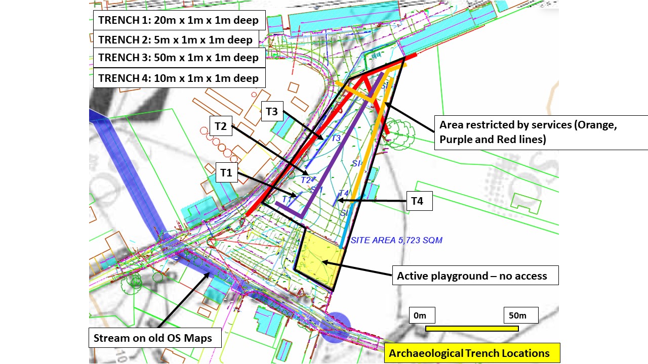
Four test trenches totalling 90m were placed to avoid the numerous existing services and the Site Investigation locations. Due to the extremely hard ground a 1m wide flat-bladed bucket had to be used instead of a 1.8m wide ditching bucket.
Results showed modern hard surfacing directly overly truncated natural ground. The natural levels were all slightly bleached blue-grey sandy clays that progressed to a more wetland clay with tiny pockets of proto-peat in the south-western corner. In the northern half of the site the natural was mixed blue-greys and orange sands and silts mixed with numerous large boulders and occasional gravel. Site investigation works showed this layer was over 2m deep. Groundwater was noted around 1m down in the southern half of the site. The whole impression is that a post-glacial channel perhaps ran through this area. By the 1837 and 1913 OS maps this had been reduced to a small stream flowing from south-east to north-west on this side of the town—but this stream, which is now culverted or at least gone from the streetscape—was at least 50m to the south of the tested area.
It is possible this relatively low, wet area of the Fair Green (currently around 105m OD) was used as a form of open, defensive area around the ‘hilltop’ town of Oldcastle (currently 109m OD – 110m OD); the centre of which is around 200m to the south-west.
No archaeological remains were uncovered at Fair Green.

