Customize Consent Preferences

We use cookies to help you navigate efficiently and perform certain functions. You will find detailed information about all cookies under each consent category below.

The cookies that are categorized as "Necessary" are stored on your browser as they are essential for enabling the basic functionalities of the site. ... 

Always Active

Necessary cookies are required to enable the basic features of this site, such as providing secure log-in or adjusting your consent preferences. These cookies do not store any personally identifiable data.

No cookies to display.

Functional cookies help perform certain functionalities like sharing the content of the website on social media platforms, collecting feedback, and other third-party features.

No cookies to display.

Analytical cookies are used to understand how visitors interact with the website. These cookies help provide information on metrics such as the number of visitors, bounce rate, traffic source, etc.

No cookies to display.

Performance cookies are used to understand and analyze the key performance indexes of the website which helps in delivering a better user experience for the visitors.

No cookies to display.

Advertisement cookies are used to provide visitors with customized advertisements based on the pages you visited previously and to analyze the effectiveness of the ad campaigns.

No cookies to display.

Excavations.ie

2024:101 - Clonmore, Stickillin, Louth

NMI Burial Excavation Records

County: Louth

Site name: Clonmore, Stickillin

Sites and Monuments Record No.: n/a

Licence number: 21E0036 ext.

Author: Gill McLoughlin

Site type: No archaeology found

Period/Dating: N/A

ITM: E 698187m, N 791055m

Latitude, Longitude (decimal degrees): 53.859655, -6.507389

Missing Mapbox GL JS CSS

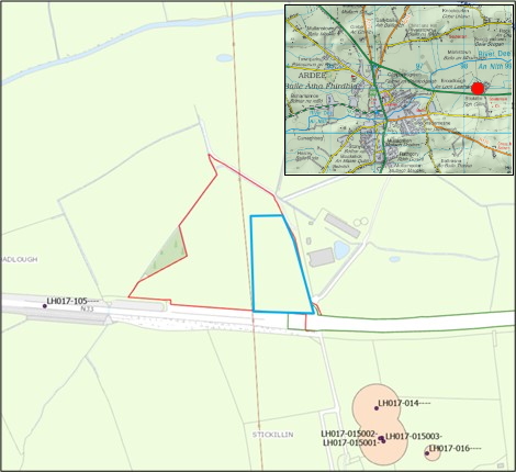
Archaeological monitoring of four geotechnical test pits was carried out pre-planning on behalf of Oriel Windfarm Ltd, relating to the proposed onshore substation location associated with the proposed Oriel Windfarm Project (offshore). The proposed substation site is located in Stickillin, Co. Louth, to the north of the N33 road and approximately 2km east of Ardee, Co. Louth.

The archaeological monitoring follows test trenching, carried out in 2021 under the same licence (excavations bulletin ref 2021:052), where archaeological remains representing burnt mound activity was uncovered.

Monitoring of the geotechnical test pits took place over one day and no features, finds or deposits of archaeological interest were identified in any of the test pits.