2024:089 - MOUNTMELLICK: No. 5, Parnell Street, Laois
County: Laois
Site name: MOUNTMELLICK: No. 5, Parnell Street
Sites and Monuments Record No.: LA008-032
Licence number: 24E0534
Author: Michael Greiner & Seán Shanahan; Shanarc Archaeology Ltd.
Author/Organisation Address: Unit 39A, Hebron Business Park, Hebron Road, Kilkenny
Site type: Pit and Field boundary
Period/Dating: Modern (AD 1750-AD 2000)
ITM: E 645143m, N 707480m
Latitude, Longitude (decimal degrees): 53.115964, -7.325668
Archaeological test-excavations were carried out on 15 May 2024, as part of an Archaeological Impact Assessment relating to the proposed development of a number of residential structures in the walled rear garden of an existing house at No. 5, Parnell Street, Mountmellick, Co. Laois. The house is a registered NIAH site (NIAH: 12900343) and a Protected Structure (RPS: 035). The south-western boundary of the proposed development area abuts the grounds of two recorded SMR sites; namely a church (LA008-032001) and graveyard (LA008-032002), and the entirety of the proposed development site falls within the Zone of Notification (Zone ID: R184840) for the historic town of Mountmellick (LA008-032).
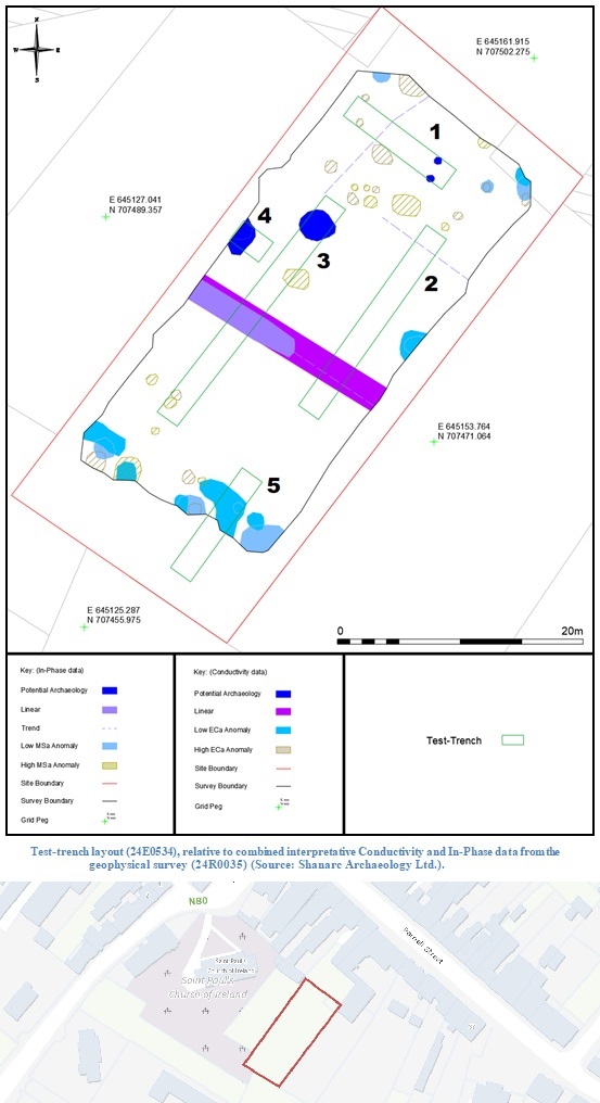
The archaeological test-excavations were preceded by a geophysical survey (Prospection Licence No. 24R0035), which was conducted by Shanarc Archaeology Ltd. on 20 March 2024.
The geophysical survey data identified multiple anomalies across the site. The majority of these anomalies were considered likely to be associated with modern garden activity, though a small number were interpreted as potential archaeology.
Test excavations comprised the excavation of five test-trenches across the site. The test-trenches were principally targeted on potential archaeological anomalies or potential features of interest identified during the preceding geophysical survey.
The stratigraphy of excavated material was generally consistent throughout all the excavated test-trenches, comprising a sod layer measuring c. 0.12m in depth overlying a c. 0.4m deep layer of mid to dark-brown topsoil, consisting of moderately compacted sandy silt with a moderate amount of small stone inclusions. The topsoil overlay natural subsoil comprised of mottled orange-grey, moderately compact gritty sandy silt with moderate amounts of small sized sub-rounded stones and occasional medium sized sub-rounded stones.
Testing identified one pit-type feature of post-medieval or modern date in test-trench 1; the pit contained waste materials in the form of brick fragments, coal, and occasional animal bone. Testing also identified a single linear feature in test-trench 2; this was interpreted as a former field/garden boundary likely relatively modern in date. Aside from these two modern features, no archaeological finds, features or deposits were identified in any of the excavated trenches.

