2024:715 - KILKENNY: No. 6, Chapel Avenue, Gardens, Kilkenny
County: Kilkenny
Site name: KILKENNY: No. 6, Chapel Avenue, Gardens
Sites and Monuments Record No.: KK019-026
Licence number: 24E0461
Author: Graeme Laidlaw; Shanarc Archaeology Ltd.
Author/Organisation Address: Unit 39A, Hebron Business Park, Hebron Road, Kilkenny
Site type: Town
Period/Dating: Modern (AD 1750-AD 2000)
ITM: E 650724m, N 655523m
Latitude, Longitude (decimal degrees): 52.648532, -7.250404
Archaeological monitoring was carried out between 25 July and 15 November 2024, in relation to the re-development of a structure at No. 6 Chapel Avenue, Kilkenny
The site falls within the archaeological Zone of Notification (Zone ID: R191607) for the historic town of Kilkenny (KK019-026—-).
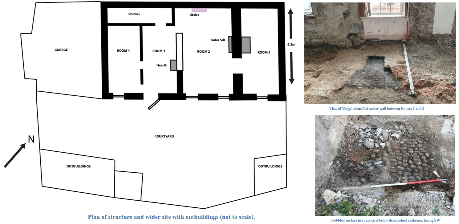
Initial monitoring comprised the demolition of two outbuildings to the south-west of the site. From cartographic evidence these structures appeared to be relatively modern. The walls were approximately 0.5m thick, and were constructed with a variety of material including cut limestone blocks at the base. Some of these were re-used cut limestone, one of which had a chamfered edge. Some slate was used between courses. A cobbled surface was identified below the outhouses, pre-dating these buildings. Cobbles were also identified within a trench excavated within the garage. Cobbles would presumably have covered the entire courtyard. These may have been from the 19th or very late 18th century. Beneath the cobbles was a dark, almost black garden soil. Several sherds of post-medieval glazed stoneware was retrieved from this soil.
Subsequent monitoring comprised the removal of a number of interior walls and floors within the existing house. A cobbled surface was found underneath the internal flagstone floor.
During removal of the wall between Rooms 2 and 3 a curved ascending feature, a chimney flue, was identified approximately 0.6m above the floor level, built on a lime mortar base 0.08m thick. Below this, what was initially believed to be a wall foundation was, upon cleaning, seen to be a large feature consisting of limestone rubble and red-brick bonded with a coarse lime mortar. It measured 1.9m from the wall and was 1.7m wide. A rectangular area measuring 0.6m x 0.38m was identified, with a black soil containing charcoal and soot. This area expanded into a wedge shape that was lined in part with redbrick. The fill included lumps of burnt coal. The feature appeared to be the remains of coal forge. The bricks in the adjoining wall may have been the associated chimney.