2024:461 - GRAIGUENAMANAGH, Kilkenny
County: Kilkenny
Site name: GRAIGUENAMANAGH
Sites and Monuments Record No.: KK029-018
Licence number: C1049, E5772
Author: Gill McLoughlin, c/o Courtney Deery Heritage Consultancy
Author/Organisation Address: Lynwood House, Ballinteer Road, Dublin 16
Site type: Historic town
Period/Dating: Late Medieval (AD 1100-AD 1599)
ITM: E 670960m, N 643720m
Latitude, Longitude (decimal degrees): 52.540195, -6.953934
Testing was carried out under ministerial consent C1049 on behalf of Kilkenny County Council relating to works associated with the proposed Graiguenamanagh—Tinnahinch Flood Relief Scheme. The aim of the testing was to inform the design process and establish a better understanding of the subsurface stratigraphy across the area.
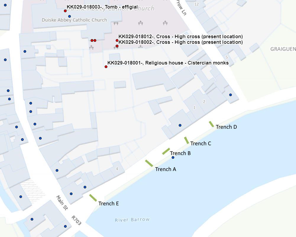
Five test trenches were excavated along the quayside in Graiguenamanagh, along the north bank of the River Barrow, within the zone of archaeological potential surrounding Duiske Abbey (KK029-018001).
The testing took place over five days from 18 November 2024 and archaeological remains or deposits of archaeological potential were identified in each of the five test trenches.
In Trench E a wall oriented north-north-west/south-south-east was uncovered at a depth of 0.5m beneath the tarmac road surface and appears to be aligned with the transept wall of the Abbey. The alignment of the wall may indicate an association with the Abbey, but its location does not appear to suggest a precinct wall. Only the east face of the wall, which is mortared, and a rubble core were present in the trench, indicating a width of at least 0.9m and a sondage indicated a surviving height of 0.55m. A metalled surface was also identified in the north-west end of the trench at 0.47m below the tarmac surface.
In both Trenches A and B a dark organic layer containing charcoal was identified, in both cases at 1.1m beneath the tarmac road surface. Sondages excavated indicated a depth of between 0.12–0.35m and no dateable finds were evident in this layer, but it is interpreted as being of archaeological potential.
In Trench B a stone drain was present at 0.4m below the tarmac road surface at the north-east end of the trench and comprised two courses of side stones and large flat capstones. This drain is probably post-medieval in date and appears to be of the same orientation as remnants of the 18th/19th-century saltworks identified during previous testing by O’Meara in 2006.
In both Trenches C and D remnants of a wall were present, oriented north-east/south-west in line with the current quay wall located c.5m away, and it could represent an earlier quay wall. In both trenches the wall had been truncated on its south-east side, leaving only the north-west face intact and it was identified between 0.65m and 0.85m below the tarmac road surface. The mortared wall measured a maximum of 0.43m wide and 0.3m in surviving height.
In both Trenches C and D a modern service was present in the north-west end, leaving a maximum of 1m of undisturbed ground between the truncation of the wall and the service trench. Sondages excavated through these areas revealed deposits of archaeological potential.