2024:214 - DÚN AILINNE, Kildare
County: Kildare
Site name: DÚN AILINNE
Sites and Monuments Record No.: KD028-038
Licence number: E4689
Author: Susan A. Johnston, George Washington University
Author/Organisation Address: 14111 Westholme Ct., Bowie MD 20715 USA
Site type: Ceremonial enclosure
Period/Dating: Multi-period
ITM: E 681962m, N 707912m
Latitude, Longitude (decimal degrees): 53.115462, -6.775661
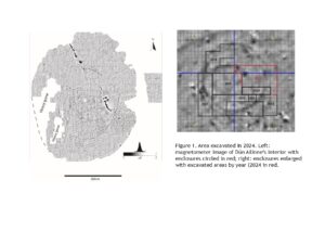
A four-week field school excavation was carried out at Dún Ailinne, Co. Kildare, from June 17–July 12, 2024, continuing the excavation of a series of ditched enclosures. Two of these were identified through a magnetometer survey (2006–2008). Both are circular and intersect each other (Fig. 1), the one to the north larger than the one to the south (21m versus 16m maximum diameter, respectively).

A third enclosure was identified in 2023, located in the same space but underlying both the northern and southern enclosure. All three are located within a large enclosure that rings the summit of the hill (identified through magnetometer survey and explored through excavation in 2016) but are about 50m to the north-northwest of the Iron Age timber structures identified in earlier excavations (1968–1975).
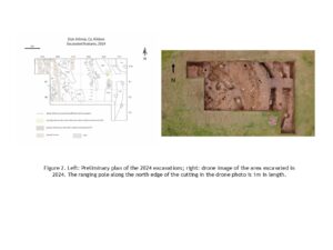
In this season, our primary goals were: 1) explore further several features of the two larger enclosures; 2) trace the continuation of the earlier enclosure and both characterize it and clarify its chronological position; and 3) explore additional features to help characterize better the functions of these features. To pursue these goals we opened an area immediately to the north of the cutting excavated in 2023 (Figure 2), encountering a maximum of 93 archaeological features (depending on how the various ditch recuts are understood).

These included the ditches of the three enclosures, a number of pits, post- and stake-holes, and a series of plough furrows.
The enclosure ditches of the three enclosures were largely the same in this season as they were in previous seasons. The single ditch of the southern enclosure and the inner and outer ditches of the double-ditched northern enclosure all appear to have been recut a number of times. All three were also cut into bedrock, though the variable depth of the bedrock made for variable ditch depths. As seen previously, the outer ditch of the northern enclosure was shallower than the inner. Stratigraphically, the southern enclosure clearly predated the northern, and the earlier enclosure, identified in 2023, was the earliest of the three. This structure, with a maximum diameter of 13m, also proved to be more elaborate. While it continued to be irregular in both profile and depth, sometimes shallowing out altogether, a line of stake-holes was identified along its inner edge.
Taken together, there would appear to be sequence of enclosure construction that, at least behaviourally, mirrors that of the larger enclosures on the summit. It is unclear if the earliest enclosure was always shallower and irregular or if this is a function of preservation, but it was certainly the smallest. This was followed by the larger and apparently deeper southern enclosure, and finally the northern enclosure, which is the most elaborate. Each of the latter two was also recut at least once, and possibly multiple times, indicating continued interest in modifying these structures. Similarly, it is also possible that the northern enclosure was originally a single-ditched feature, with the outer ditch being added later. Whether this sequence reflects continual rebuilding of different versions of the same monument or instead represents three discrete phases of the use of this area (potentially separated by significant periods of time) is uncertain.
In addition to the enclosures, we excavated seven plough furrows; a linear feature and several pits associated with the southern enclosure ditch; several clay deposits; and a number of other pits, post- and stake-holes. Apart from the stake-holes along the inner edge of the earlier enclosure, the majority of the stake- and post-holes were clustered in the northwest and southwest of the cutting. By themselves they did not show any obvious patterns, and many of them may be related to the construction, reconstruction and/or maintenance of the enclosure ditches. The linear feature (F302) was perpendicular to the western side of the ditch and oriented north-east/south-west. Its stratigraphic relationship with the ditch is uncertain but it certainly abutted it on the ditch’s southern edge. Three of the clay deposits were on the surface of the inner ditch of the northern enclosure, while the fourth one was only seen in section in the north-east corner of the cutting.
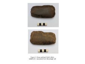
As is typical at Dún Ailinne, few artefacts were recovered from the features excavated. There were eleven in total, seven of them lithics, including a stone axe head, E4689:257, recovered from the plough soil (Fig. 3).

A single ceramic sherd, E4689:260, was recovered from a plough furrow, and two iron objects and a fragment of slag were also found (Fig. 4). E4689:263 was a nail fragment from a pit in the south-west corner of the cutting and E4689:259 was a cylindrical piece (a nail shaft fragment or perhaps a piece of slag) from the linear feature adjacent to the southern enclosure. The slag came from the plough soil. In addition to these artifacts, fragments of a pig cranium, which included articulated teeth (E4689: 268) were recovered from the inner ditch of the northern enclosure in E10, from a layer within the basal fill of this feature but on the edge of the ditch. Other fragments of faunal material included tooth enamel from a sheep or goat and a large number of fragments of calcined bone. The latter in particular were ubiquitous—of the 99 contexts excavated, 22 of them contained calcined bone, most of it highly fragmented. With a few exceptions, this could not be identified as to species, and while it is likely that it is non-human animal, the possibility of human remains cannot be ruled out. That said, the calcined bone was largely diffuse and could not be said to represent a true deposit anywhere it was encountered. Several samples were collected, including one (E4689:269) with visible cut marks, in case further analysis of this material becomes possible. Charcoal was also collected from ten contexts and four of these will be submitted for radiocarbon analysis following species identification.
All artefacts and samples are now in the National Museum.
