2024:072 - SAWYERSWOOD, Kildare
County: Kildare
Site name: SAWYERSWOOD
Sites and Monuments Record No.: N/A
Licence number: 24E0365
Author: Muireann Ni Cheallachain
Author/Organisation Address: Apt 63 Eden Wood, Delgany, Co. Wicklow. A63 N251
Site type: No archaeology found
Period/Dating: N/A
ITM: E 669159m, N 696667m
Latitude, Longitude (decimal degrees): 53.016227, -6.969299
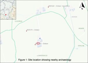
Archaeological monitoring was undertaken in response to a condition of planning permission, granted by Kildare County Council. The development is located in Sawyerswood townland in Co. Kildare c. 2.58km to the northeast of Athy, in a rural setting within an existing farmyard to the rear of Sawyerswood House. An enclosure (KD035-076) identified during an aerial photographic survey by Dr. Gillian Barrett on 13 July 1989 is located c. 32m to the southwest of the development in a large tillage field. Aerial photograph (GB90.BB.37) shows a cropmark of a curvilinear enclosure defined by a fosse and with an entrance facing north-east. The enclosure is not indicated on the historic OS mapping and has no surface visibility; however, it is visible on a later aerial photograph accessible on Historic Environment Viewer (2011–2013) (Figure 6). A second enclosure (KD035-075) also identified during the aerial photographic survey is located 229m to the northwest of the development.
Monitored groundworks consisted of the removal of topsoil and the modern berm of redeposited soil, to natural subsoil level using a 13-tonne tracked mechanical excavator with a flat grading bucket. A metal detection survey of all removed topsoil was undertaken under licence 24R0206 as per condition 4a of the planning permission.
Nothing of archaeological significance was identified during the course of monitoring and no artefacts were recovered from the metal detection survey.
 Site location plan
