2024:760 - DUBLIN 2: Harcourt Square, Harcourt Street and Charlotte Way, Dublin
County: Dublin
Site name: DUBLIN 2: Harcourt Square, Harcourt Street and Charlotte Way
Sites and Monuments Record No.: N/A
Licence number: 23E0013
Author: Siobhán Deery
Author/Organisation Address: First Floor, Unit 5B, Block F, Nutgrove Office Block, Rathfarnham, Dublin 14, D14Y8C9
Site type: Town
Period/Dating: Modern (AD 1750-AD 2000)
ITM: E 715639m, N 732960m
Latitude, Longitude (decimal degrees): 53.334233, -6.263749
The monitoring of bulk excavation and ground reduction works was carried out between July 2023 and May 2024 at a large-scale development at Harcourt Square, Harcourt Street and Charlotte Way, Dublin 2.
Cartographic sources indicated that Harcourt Street was laid out in 1777, and by 1843 it contained seventy-two houses. The protected structures at Nos 39 and 40 Harcourt Street appeared as the two southernmost buildings at the end of a terraced row. John Hatch, a graduate of Trinity College Dublin and a barrister, constructed the largest and widest house on the street at No. 40 for his own residence; he died there in 1797.
With the exception of No. 39 Harcourt Street, the remainder of the site—including the rear of No. 40—was redeveloped in its entirety during the 1970s. Prior to this, the area had formed an enclosed garden associated with No. 40, a late-eighteenth-century townhouse that was incorporated into the later construction. The 1970’s basement structure had been excavated to boulder clay, removing all earlier deposits from the site. Archaeological monitoring of site investigation (SI) works, undertaken under licence 19E0118, confirmed that the 1970’s redevelopment had reduced the site to sterile fill and natural clay, and overlain by a thick reinforced-concrete slab.
Monitoring of the bulk excavation works across the site similarly revealed no features, finds, or deposits of archaeological significance. However, the below-ground remains of the late-eighteenth-century eastern boundary wall that once enclosed the garden of No. 40 Harcourt Street were exposed (F1). Owing to its substantial depth (c. 1.6m exposed height), the wall may also have functioned as a revetment along Harcourt Street. As it lay outside the foundation footprint of the proposed development, the wall was preserved in situ and backfilled, with a 2m section broken through to accommodate drainage.
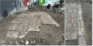
Ground reduction to the rear of No. 39 Harcourt Street exposed the remains of a former paved courtyard (F2) together with the original western and southern boundary walls (F3 and F4), both of which were in extremely poor condition. The yard area had been infilled or raised with material interpreted as construction debris and soils associated with late-eighteenth- or early-nineteenth-century development of the site.
No features or deposits of archaeological significance were identified during the monitoring works.