2024:530 - DUBLIN 6W: 126–128 Harold's Cross Road, Dublin
County: Dublin
Site name: DUBLIN 6W: 126–128 Harold's Cross Road
Sites and Monuments Record No.: N/A
Licence number: 19E0690 ext.
Author: Thaddeus Breen; Shanarc Archaeology Ltd.
Author/Organisation Address: Unit 39a, Hebron Business Park, Hebron Road, Kilkenny
Site type: House - 19th/20th century
Period/Dating: Modern (AD 1750-AD 2000)
ITM: E 714597m, N 731917m
Latitude, Longitude (decimal degrees): 53.325090, -6.279764
Archaeological monitoring was carried out during periods of groundworks associated with the redevelopment of a site at 126–128 Harold’s Cross Road, Dublin 6W, between April 2023 and July 2024.
No. 126 was demolished subsequent to the preceding test excavations (19E0690), along with the outbuildings behind it, and the ground level on the site of the latter was reduced, removing any further trace of the cobbled surface identified during testing. House and outbuilding demolition was carried out without informing Shanarc Archaeology, so this part of site construction was not archaeologically monitored.
Monitoring of groundworks began in April 2023. Several preliminary groundworks were carried out and monitored between this date and late June. From June to September 2023 secant piling took place. This required continuous monitoring. The first phase of bulk excavation took place from October 2023 to January 2024. This likewise required the continuous presence of an archaeologist on site. Following this, the western building—Block 1—was constructed, and there were no further groundworks until June 2024, when the second phase of bulk excavation took place. This finished on 8 July 2024, and the front (east) building—Block 2—commenced. This marked the end of groundworks on site.
The main features of the site at 126–128 Harold’s Cross Road were the remains of houses, gardens and garden/yard walls, and evidence of the artificial raising of the ground level across a sloping site in the 20th century. Garden/yard walls associated with the houses were found in the course of the bulk excavation.
The houses and associated garden/yard walls were in existence by at least 1843, when the Ordnance Survey six-inch map was published. They formed part of the village of Harold’s Cross, which was centred on what is now Harold’s Cross Park, but was then an open green. The garden/yard walls contained gravestone fragments, likely sourced at a ‘Monumental Works’ established in the 19th century at Mount Jerome Cemetery, and may have been used in wall repairs.
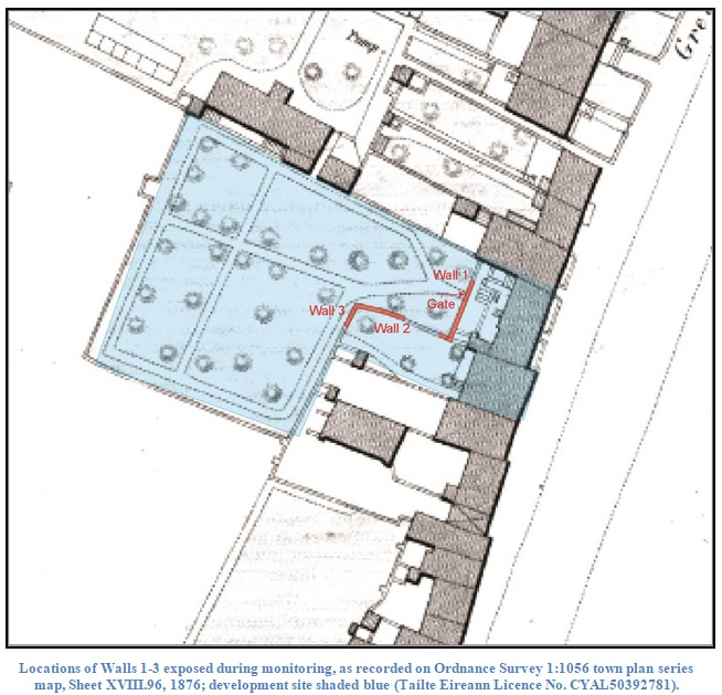
The land sloped down from the road to the River Poddle, and would have been liable to flood regularly, which was why the level of the site was raised. The buried garden/yard walls at the site suggest these originally sat at a lower level to the houses, and steps in the rear yard to No. 126 are clearly shown on the Ordnance Survey 1:1056 town plan series map, dated 1876, indicating at least part of the rear yard and the whole of the garden was at a lower level to the house. The former ope or gate into what was once a formal garden at No. 126 was recorded in Wall 1.
The large quantity of artefacts found during both piling and the bulk excavation is comprised of late 19th- and 20th-century material, and suggests that much of the infill here was done by dumping refuse.
No evidence was found of any earlier buildings or activity.