2024:400 - RATHFRILAND: Rathfriland Health Centre, 87–95 Newry Street, Down
County: Down
Site name: RATHFRILAND: Rathfriland Health Centre, 87–95 Newry Street
Sites and Monuments Record No.: N/A
Licence number: AE/2024/078
Author: Eoin Halpin, AHC Ltd.
Author/Organisation Address: 36 Ballywillwill Road, Castlewellan, Co. Down BT31 9LF
Site type: Kiln - brick
Period/Dating: Modern (AD 1750-AD 2000)
ITM: E 719424m, N 833920m
Latitude, Longitude (decimal degrees): 54.240191, -6.167850
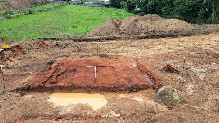
An archaeological impact assessment (AIA) was undertaken on behalf of Brian McConville MJM Group, in response to a proposed development on lands to the rear of 87–95 Newry Street, Rathfriland, Co. Down consisting of an integrated medical village, associated services, access roads and carpark and to create a new entrance in the terrace of buildings fronting onto Newry Street. The results of the AIA, which was carried out in June and July 2023 under license AE/23/061, revealed nothing of archaeological significance apart from the presence of a quarry pit and a 19th- or early 20th-century brick kiln, both of which had been recorded on the OS map of 1903. The quarry pit had remained open and in use until the middle of the 20th century. The remains of the brick kiln were limited to its basal layers. The area of the kiln was backfilled for its protection at the end of the assessment phase.
In 2024 permission was sought and a license granted, AE/2024/078, for the excavation of the kiln site and an area extending to 10m around the kiln remains. This work was undertaken in June 2024. From results of the excavation, the size of the kiln floor, the layout and of the surviving bricks and the specialist report on the brick sample, it was concluded that the Rathfriland remains consisted of a ‘clamp kiln’. This method of brick manufacture involved the ‘green’ bricks being stacked on the ground in rows or ‘benches’ and alternate header and stretcher layers built up to form an externally battered structure. The gaps between the lower rows of bricks were filled with fuel (peat or wood) and ignited. These gaps would have facilitated a through draught. The clamp would have burned for a number of days or weeks before the finished bricks could be taken down ready for use. The cycle of operations was repeated when required, with the clamp having to be built again from scratch each time brick firing was required. The remains at Rathfriland are evidence for this type of kiln. Gullies on the upslope, west and northern margins of the kiln acted as drains keeping the kiln floor area relatively dry, with the run-off diverted down slope to the northeast. Some evidence was found for the ‘benches’, which were laid out in rows, the continued lines of which were reflected in the alternate patterning of dark and light stripes across the kiln floor. The darker stripes are readily attributed to the lines where the fuel was placed, and the lighter areas mark the lines of the benches. A very dark spread of material at the open, south end of the kiln, is likely evidence for the continued rake-out of the burnt remains, post-firing. The specialist brick report noted that the bricks recovered from the floor of the kiln had been left with the clamp remains when it had been dismantled, sorted and removed, so they were likely to have been among the poorest quality of brick as any saleable items would have been collected. The report further concluded that given the poor quality and handmade unperforated nature of the bricks, it could be assumed they were made pre-major industrialisation of the brick making process, which began in the 1850s, and therefore date probably to the first half of the 19th century, rather than a period when the brickfield illustrated on the OS 6 inch maps were operational, the later 19th or early 20th century.