2024:790 - NM20 Cork - Limerick road, Cork
County: Cork
Site name: NM20 Cork - Limerick road
Sites and Monuments Record No.: CO051-031, CO051-133, CO051-135, CO042-051001/002, CO017-062, CO008-027, CO002-055, CO002-018, LI021-158, LI021-020, LI030-177/134
Licence number: 24E0278
Author: Gill McLoughlin
Author/Organisation Address: c/o Courtney Deery Heritage Consultancy, Unit 5B, Block F, Nutgrove Office Park, Rathfarnham, Dublin 14
Site type: Various
Period/Dating: N/A
ITM: E 554380m, N 616260m
Latitude, Longitude (decimal degrees): 52.296104, -8.668804
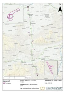
Archaeological testing was carried out in phases between 27 February 2024 and 6 December 2024 along the emerging preferred route of the NM20 Cork – Limerick road. The purpose of the programme of testing was to target anomalies identified in geophysical survey, LIDAR survey or aerial photography and to establish if the identified anomalies are archaeological, and if so, the nature, extent and character of any remains. Testing was also carried out in the vicinity of recorded monuments which were not represented in the above surveys.
Testing was carried out at 19 of 21 initial proposed test locations, comprising 48 trenches measuring 1477 linear metres. Five of the proposed trenches in Killeen townland, Co. Limerick were not tested due to an issue with landowner access.
During the course of the project, an additional five trenches at Croom, Co. Limerick were added to the testing programme to assess the archaeological potential of a proposed associated transport hub at Croom, adjacent to Croom Castle and Town Defences (LI030-025005 and LI030-025009). Five trenches measuring 182 linear metres were excavated at Croom.
In total 53 trenches totalling 1659 linear metres (3318m²) were excavated across 20 test locations.
Test Area 1, Rathduff, Co. Cork
Two trenches targeted sub-surface enclosure CO051-135 and the enclosing element of the ditch was identified, measuring 5.45m wide on the surface but included a very gradual slope for the first c.1.8m resulting in a more realistic width of 3.65m. It measured in excess of 1.6m deep. No dateable artefacts were recovered from the fills, however given the size and morphology of the site and the types of sites in the surrounding landscape, it is thought most likely to be a Ringfort.
Test Area 2, Rathduff, Co. Cork
One trench targeted a curving anomaly identified in the geophysical survey and a large ditch measuring 5.3m wide and 1.35m deep was identified in the trench. No dateable artefacts were recovered from any of the fills. Based on the morphology of the ditch and the nature of the fills, combined with the topography immediately to the south and southeast of the test area and south of the extant field boundary, where the ground drops away quite sharply but leaves an impression of a raised semi-circular area, it appears that the curving ditch may be an enclosing feature. The sharp drop in ground level to the south, in conjunction with the curving ditch could have formed an enclosure . Based on the number of ringforts in the immediate surrounding area, the site may be another ringfort.
Test Area 3, Rathduff, Co. Cork
Three large ditches corresponding closely with the anomalies indicated in the geophysical survey were identified in testing and represent a trivallate enclosure (SMR CO051-133). The middle and largest of the ditches measured 6.5m wide and 1.6m deep (4m wide ditch proper with 2.5m shallow step on inner side) and the outer and inner ditches were similar in size measuring 3.1m wide and 1.15m deep and 2.6m wide and 1.14m deep respectively. No dateable artefacts were recovered from any of these sections. A spread identified in the trench is likely to relate to internal occupation activity. Possible external ditches indicated on geophysical survey proved to be variations in the natural subsoil and are not of archaeological interest.
Test Area 4, Rathduff, Co. Cork
Two trenches targeted a sub-surface enclosure identified on the geophysical survey and the enclosing ditch was identified in both trenches, measuring between 2.55-2.6m wide and 1.05m deep. Several fills were noted in both test sections and no dateable artefacts were recovered. The enclosure measures approximately 31m in internal diameter and, based on the proximity of several ringforts in the immediate vicinity, this site is thought most likely to be a ringfort.
Test Area 5, Lissavoura, Co. Cork
The area adjacent to a recorded burial ground (RMP CO051-031) was tested and no evidence for any burials or other archaeological features was identified.
Test Area 6, Burnfort, Co. Cork
The area adjacent to an upstanding ringfort and souterrain (RMP CO042-051001-002) was tested and geophysical anomalies targeted. Several small-scale cut features were identified, consistent with peripheral features associated with the RMP site.
Test Area 7, Ballyvorisheen, Co. Cork
One trench targeted a sub-surface enclosure identified on geophysical survey and the features in the trench corresponded very closely with the anomalies indicated in the survey. A large enclosure ditch with associated internal and external features was identified in the trench. No dateable artefacts were recovered from any of the features and while it was not possible to establish the type of enclosure site, it is thought most likely to belong to the ringfort tradition.
Test Area 8, Knockanare, Co. Cork
Three trenches were excavated to test the site of a recorded sub-surface enclosure (RMP CO017-062) of which there was only a slight indication on geophysical survey. The enclosure ditch was identified in all three trenches, along with internal and external features and no dateable artefacts were recovered from any of the investigated features.
Test Area 9, Castlewrixon South, Co. Cork
Seven trenches were excavated in one large field to assess the potential for a castle site reputed to be in this general location. The trenches targeted various geophysical anomalies and no features of archaeological significance were identified in any of these trenches.
Test Area 10, Castlewrixon, Co. Cork
Testing targeted a possible bivallate enclosure as well as possible wall footings indicated on geophysical survey. Two ditches representing the inner and outer ditches in the enclosure were identified and the other anomalies proved to be not of archaeological interest.
Test Area 11, Kiltoohig, Co Cork
One trench targeted the enclosing element of a large enclosure recorded as a moated site (CO002-055) and a large ditch, broadly corresponding with the geophysical survey results and with a visible surface depression, appearing circular on the surface, was identified. The ditch measured approximately 10m wide and a test section was excavated to 1.1m in depth but the full depth was not established due to rapid ingress of water from below. There was a considerable amount of modern disturbance apparent, consistent with large scale, relatively recent backfilling of the ditch and this corresponds well with the SMR record which states that, according to local information, the site was levelled c.1977. No artefacts or environmental material was recovered from the ditch to assist in further interpretation of a site type or dating. Contrary to the geophysical results there is no evidence that the enclosure is bivallate.
Test Area 12, Gortskagh, Co. Cork
Two trenches were placed to assess the nature and extent of an earthwork (CO002-018) which presented in the field as a raised area. The raised area appeared to be geological in nature, however a possible linear ditch or elongated pit and a small pit identified in the trenches are of archaeological interest.
Two further trenches targeted a possible moated site indicated on LiDAR and geophysical survey and a large ditch was identified in both trenches, corresponding with the anomaly indicated and with a visible depression on the surface of the field which coincides with different vegetation. The feature measured between 4.1–4.5m wide and the base was reached at just 0.25m depth in one trench and it was only possible to test it to 0.4m depth in the other trench due to rapid ingress of water from below. Modern bottle glass and a plastic shopping bag were present in the base of the ditch here. The waterlogged nature of the ditches could support the interpretation of this as a moated site, however there was no indication either in the fills or the inclusions to support it being archaeological in nature and the presence of modern rubbish in the base of the ditch in Trench 34 suggests it is a modern feature and not of archaeological interest.
Test Area 13, Kingsland, Co. Limerick
Two trenches targeted a possible moated site indicated on geophysical and LiDAR surveys and a ditch measuring 4.6m wide and 0.95m deep was identified in one of the trenches, corresponding with the surveys. In the other trench a shallow linear feature measuring 1.8m wide x 0.3m deep corresponded with the geophysical survey. Neither feature contained any diagnostic finds or dateable material and it is unlikely that the features uncovered here represent a moated site, but several spreads and shallow pits identified in one of the trenches may be an indication of archaeological activity, possibly burnt mound activity, in the vicinity.
Test Area 14, Dohora, Co. Limerick
Two trenches targeted a possible moated site indicated on geophysical and LiDAR surveys and ditches corresponding with the surveys were present in both trenches. The ditch contained largely sterile fills and no diagnostic finds were retrieved. Internal to the possible enclosure, a metalled surface associated with charcoal and animal bone was identified, as well as a possible rectangular foundation slot. The ditch measured 4m wide and was only tested to 0.9m deep due to rapid ingress of water.
It seems likely that the features uncovered in Test Area 14 represent a large rectilinear enclosure, probably a moated site, and despite the fact that no dateable artefacts were recovered, evidence for internal features of an archaeological nature support this interpretation.
Test Area 15, Dohora, Co. Limerick
One trench targeted a possible bivallate enclosure indicated on geophysical survey and the outer ditch-type anomaly proved to be a geological feature. The anomaly interpreted as the possible ‘inner enclosure’ indicated in the geophysical survey was identified within the trench, truncated by two stone drains, but a section across this area revealed an irregular cut measuring c.2.5m wide and 0.95m deep which may represent a waterhole or pond-type feature. It is not clear whether this feature represents archaeological activity, and if it does, it is unclear what exactly the nature of that may be. A shallow linear feature and a shallow pit identified in the trench are, however, deemed to be of archaeological potential. No artefacts were recovered from any of the test sections investigated to assist with the interpretation of the function or dating of these potential archaeological features.
While some features of archaeological potential were identified in Test Area 15, there was no evidence for the bivallate enclosure detected by geophysical survey. The most likely origin for the geophysical anomalies are changes in the natural subsoil.
Test Area 16, Fanningstown, Co. Limerick
The location of a recorded enclosure (RMP LI021-158) was targeted to confirm or deny the presence of an enclosure or other archaeological features. No features, finds or deposits of archaeological interest were identified and the recorded enclosure does not exist in this location.
Test Area 17, Killeen, Co. Limerick
Two trenches were excavated to target a possible square enclosure and linear anomalies which were indicated on geophysical survey. The square anomaly corresponded with variations in the natural subsoil and the other features targeted were consistent with shallow linear drainage or agricultural features and were not deemed to be of archaeological interest.
Test Area 18, Killeen, Co. Limerick
One trench targeted a possible curving ditch indicated on geophysical survey to assess the possibility of it being associated with a Children’s Burial Ground immediately to the west (RMP LI021-020). A ditch measuring 1.8m wide and 0.6m deep identified in the trench corresponded with either a linear trend or a curving ditch-type anomaly identified in the geophysical surveys. The ditch possibly represents an outer enclosure ditch associated with the RMP site. It measured 1.8m wide and 0.6m deep and the only notable inclusion in the fills was frequent snail shell in the lower fill. The archaeological potential of this feature cannot be ruled out at this stage although is noted that this feature is quite small to be an enclosure ditch, which may point to it being an agricultural or drainage feature instead.
Test Area 19, Ballybronoge South, Co. Limerick
Three trenches were excavated, targeting geophysical anomalies representing a possible sub-circular enclosure, a possible sub-rectangular enclosure and a control trench across an irregular anomaly. Many of the anomalies relate to geological trends. Two ditches uncovered in the trench targeting the possible sub-circular enclosure were not substantial features and they did not contain any fills, finds or inclusions suggestive of archaeological activity. Based on the results of the testing and the cartographic evidence, which shows a curving field boundary continuing to curve away to the west, it is thought unlikely that this feature relates to an enclosure.
Croom Transport Hub, Co. Limerick
No geophysical or other surveys were carried out at the Croom testing location and the aim was to cover as wide an area as possible with the trenches. A metalled pathway oriented northwest-southeast, corresponding with one depicted on the first edition OS 6-inch map between the castle to the south and the church to the north, was identified in the south of the test area. In the north of the test area multiple pit-type features were uncovered and there was a depth of overburden in the northeast of the area up to 1.1m deep. A sherd of medieval pottery was recovered from one of the pits and two refitting halves of a hammerstone were recovered from two of the pits. There was also a scattering of pits/spreads in the other trenches, which in the absence of any dateable finds are assumed to be of archaeological potential.