2024:611 - GLANMIRE: Glanmire Bridge, Glashaboy River, Cork
County: Cork
Site name: GLANMIRE: Glanmire Bridge, Glashaboy River
Sites and Monuments Record No.: CO075-048
Licence number: 24D0191, 24R0276
Author: Rex Bangerter, ADCO
Author/Organisation Address: No. 2, Main Street, Bennettsbridge, Co. Kilkenny
Site type: Bridge
Period/Dating: Modern (AD 1750-AD 2000)
ITM: E 572752m, N 574174m
Latitude, Longitude (decimal degrees): 51.919027, -8.396107
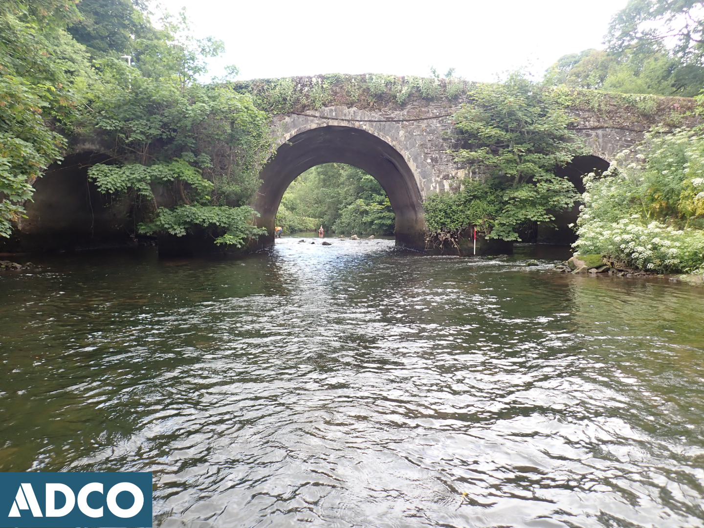
Glanmire Bridge, which crosses the Glashaboy River at ITM 572752E, 574174N, comprises a four-arched structure of late eighteenth-century date. The bridge is humped-backed, comprising a large arch to channel centre, flanked by two smaller arches on the east and west sides of the river. The fourth arch is located c. 10m to the east, where it originally accommodated an adjacent millrace. The arches are rounded in form with dressed limestone voussoirs. The bridge is of random rubble construction with a mix of limestone and sandstone used throughout. V-shaped cutwaters adorn the upstream side of the two in-water bridge piers.
The bridge is a recorded monument (RMP CO075-048—-) and is also included in the NIAH (20907505) and the Record of Protected Structures for Cork City (RPS 1181).
The UAIA comprised systematic survey and visual inspection of the Glashaboy River, extending 41m upstream and 48m downstream of Glaminre Bridge; ITM 572742E, 574217N – ITM 572765E, 574121N. The assessment, which was conducted on 10 June 2024, sought to provide a detailed account of the existing river environment; recording riverbed topography, assessing the potential of the riverbed deposits to retain archaeological material, and identifying any additional features/structures of archaeological or historic significance that may be present. In addition, targeted metal-detection was employed to help assess the riverbed and highlight any metallic concentrations present.
The river is fast flowing and juvenile in nature, being quick to rise and fall during/after flooding events. The channel varies between 12m and 23m in width across the assessment area and measures 22.62m in width at the bridge location. A maximum water depth of 800mm was encountered at a point c. 35m upstream of the bridge, on the west side of the channel. An average water-depth of 370mm was present for the riverbed upstream/downstream of the bridge structure.
The riverbed is composed of a compact deposit of sub-rounded to angular pebbles (50mm) and cobbles (<200mm), with frequent sub-angular boulders (<350mm). Occasional patches of sand and gravel were also observed.
Four features of archaeological/historical interest were present within the assessment area. These included: Glanmire Bridge (Feature 1); a section of river-walling that delineates the west side of the channel (Feature 2); an adjacent millrace (Feature 3), located c. 10m to the east of the river channel; and an associated sluice structure (Feature 4), located c. 43m downstream of Glanmire Bridge.
Glanmire Bridge (Feature 1) is to undergo conservation grade repair, the rehabilitation works to comprise the removal of vegetation from the bridge façades, the repair/repointing of the wing/spandrel walls, including the upstream cut-waters, and the rebuilding of any damaged sections of bridge parapet. Features 2-3 remain outside of the proposed works boundary of the bridge rehabilitation project.