2024:543 - MIDLETON: Ballyvodock East, Cork
County: Cork
Site name: MIDLETON: Ballyvodock East
Sites and Monuments Record No.: N/A
Licence number: 24E0697
Author: Graeme Laidlaw & Seán Shanahan; Shanarc Archaeology Ltd.
Author/Organisation Address: Unit 39a, Hebron Business Park, Hebron Road, Kilkenny
Site type: Pit, Kiln, Linear earthwork and Enclosure
Period/Dating: Undetermined
ITM: E 586085m, N 570823m
Latitude, Longitude (decimal degrees): 51.889398, -8.202151
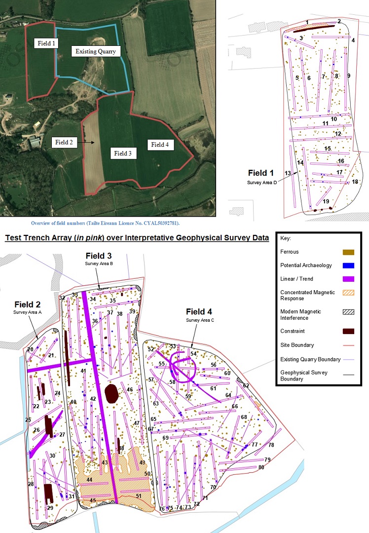
Archaeological test-excavations were carried out from 11-13 September 2024 to further inform an Archaeological Impact Assessment as part of an EIAR relating to the proposed extension of a quarry/sandpit at Ballyvodock East, Co. Cork.
Test-excavation was preceded by a comprehensive geophysical survey of the subject lands carried out by Shanarc Archaeology Ltd. on 16 July 2024 under survey licence no. 24R0325.
The geophysical survey data produced evidence of multiple linear features, one possible enclosure, and numerous potential archaeological pit-type features,
A total of eighty test trenches were excavated within the boundary of the proposed quarry extension, targeting those areas where the geophysical survey had detected anomalies of potential archaeological significance. The general stratigraphy within the trenches was relatively consistent across the site, consisting of light to mid- brown sandy silt topsoil with moderate amounts of rounded and oval pebbles and some larger, occasionally split pebbles, overlying mixed subsoil. Most of the excavated trenches revealed evidence for relatively recent activity in the form of plough furrows, agricultural machine ruts and drainage ditches.
Evidence for archaeological activity was identified in twenty-nine trenches, primarily in the form of pits, linear features and burnt spreads along with three possible kilns. In total, fifty-three archaeological features were identified. No artefactual evidence was found in any of the excavated test trenches.
The majority of the identified features can be matched to anomalies identified as potential archaeology in the geophysical survey data, though a large number of the geophysical anomalies investigated also proved to be natural features. No features of archaeological significance were identified in Field 1. Eight features were identified in Field 2, two in Field 3, and forty-three in Field 4. In several instances, multiple features were identified within a single trench, suggesting areas of potential concentrated activity within the wider site. Several ditches and linear features seem to correspond to a circular enclosure in the north of Field 4 that was identified during the geophysical survey. Given the number of identified features within the comparatively small areas covered by the test trenches, it is possible that there are additional features, possibly of a similar nature to those already identified, within the untested areas of the site.