2024:524 - BALLYNANELAGH, Cork
County: Cork
Site name: BALLYNANELAGH
Sites and Monuments Record No.: N/A
Licence number: 24E0031
Author: Katarzyna Labaj
Author/Organisation Address: 195 Shanakill, Tralee, Co. Kerry
Site type: Enclosure, Fulacht fia and Pit
Period/Dating: Prehistoric (12700 BC-AD 400)
ITM: E 577545m, N 578043m
Latitude, Longitude (decimal degrees): 51.954020, -8.326685
Licensed archaeological testing was undertaken in mid-February 2024 with regard to a planning application to construct an energy storage system and associated infrastructure at Ballynanelagh, Co. Cork.
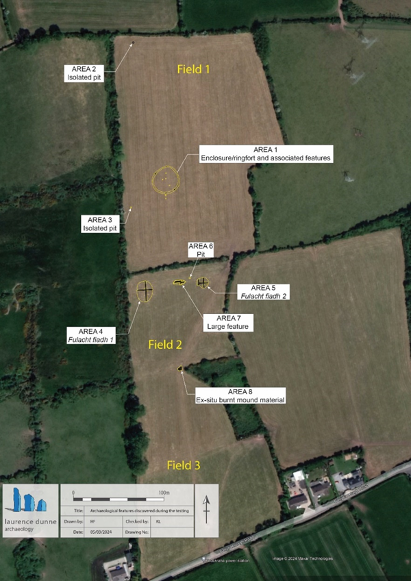
A series of thirty-seven test trenches (T1-T37) with a total length of c.4,360m were excavated across the proposed development site. Nine of thirty-seven test trenches were targeted on the location of the most significant anomalies recorded during the geophysical survey (Nicholls 2023). Eight areas of archaeological interest were discovered and recorded during the testing program, including:
- Area 1: Large sub-circular ditched enclosure (possible ringfort) 27m x 25m that precisely corresponded with the geophysical survey results and four possible associated internal features (pits & post-holes).
- Area 2: Isolated pit feature (dims. c.2m x 1.2m) with obvious fulacht-type material.
- Area 3: Isolated pit feature (dims. 0.8m x 0.6m) containing charcoal-rich black sandy clay with heat-shattered stone inclusions.
- Area 4: Fulacht fiadh (FF1) found at the location of the geophysical anomaly recorded during survey. The mound was visible prior to excavation as a clear rise in the ground. An east-west orientated offset cutting was excavated to establish its full extent which revealed a max dimension of 23m north-south x 20m.
- Area 5: Fulacht fiadh (FF2). A second smaller and more disturbed/levelled fulacht fiadh (c.14m east-west x 12m) was found 50m east of FF1.
- Area 6: A sub-circular pit (c.1.25m in diameter) consisted of typical fulacht material with heat-affected stone and charcoal was recorded in c.8m north-west of FF2 and most likely contemporaneous with it.
- Area 7: Large (c.12m east-west x 6m) possible feature of uncertain function containing an amount of waterlogged wood. It comprised of soft waterlogged timbers disposed within mid-grey to dark material with frequent wood fragments different type and size. Charcoal chunks and some heat-shattered stones were also noted. No definite structure or worked wood was recorded. However, due its spatial location between the two fulachta fiadh and the near proximity of the pit (Area 6), the feature may be associated/related to them.
- Area 8: Possible ex-situ burnt mound material with exposed dimensions of c.9m x 5m was found just under a thin layer of sod in the southern end of T37. It is possible that the material was most probably brought here in the past to dry and fill this very wet and lowest point of the field and to harden the surface.
Artefactually, a possible flint scraper was recovered from the topsoil during testing.
Reference
Nicholls, J. (2023) Geophysical survey report. Proposed battery storage site at Knockraha, Ballyanelagh townland, County Cork, Licence no.23R0410. Unpublished report, Target Archaeological Geophysics.