2023:127 - AVOCA RIVER, Tinahask Lower, Wicklow
County: Wicklow
Site name: AVOCA RIVER, Tinahask Lower
Sites and Monuments Record No.: N/A
Licence number: 22D0084
Author: Una Cosgrave Hanley, AMS
Author/Organisation Address: Fahy's Road, Kilrush, Co. Clare
Site type: Wreck
Period/Dating: Undetermined
ITM: E 724994m, N 673143m
Latitude, Longitude (decimal degrees): 52.794795, -6.146584
A survey was carried out on the Avoca River to test the application of multi-beam technology for archaeological purposes within shallow waters. The survey was carried out using an unmanned surface vehicle (USV) operated by Survey Genix in collaboration with Archaeological Management Solutions (AMS).
Several potential archaeological features have been previously identified in the Avoca River by The Archaeological Diving Company (ADCO) who carried out underwater archaeological surveys in 2018 and 2019.
This survey took place on 9 February 2023. A total of 9,364 sq.m of riverbed was surveyed:
7,708 sq.m downstream of Arklow Bridge in Area 1; and 1,656 sq.m in Areas 2 and 3 upstream of the bridge.
Potentially archaeologically significant anomalies were identified which will require further survey—dive and remote—to identify their nature and significance.
The multi-beam hydrographic survey using the USV successfully demonstrated the benefits of carrying out a bathymetric survey of the riverbed using wirelessly controlled technology on remotely operated and autonomous vehicles, albeit for a limited Survey Area. Of the potential 10.38ha Survey Area, a total of 9,364 sq.m of riverbed (9%) was surveyed between 11:00 and 16:40 on 9 February 2023. A total of 35 (no.) anomalies were identified. The majority (24) of these anomalies are thought to be archaeologically significant. All of the potentially archaeological features are found in Areas 1 and 2, and all of the potential wrecks are found in Area 1. The remaining identified features are thought to be geological (two) or possibly geological (nine) (Figure 8 -Figure 10; Appendices 3 and 4).
2 The USV multi-beam hydrographic survey also provided useful information on the topography and profile of the riverbed (Figure 5–Figure 7 and Figure 11–Figure 13).
Five possible wrecks have been identified in Area 1: GL11, GL12, GL13, GL22, and GL23 (Appendices 3 & 4). These consist of features between 1m and 1.7m below the surface, and range in size from 0.97m and 7.9m long, and from 0.57m and 1.8m wide and protrude between 0.18m and 0.8m high above the surrounding riverbed. GL11 is a linear feature orientated east−west and is probably geological but has the dimensions and shape of a small boat with the bow section broken off at the western end.
GL12 and GL13 are probably boulders but may be related to a wreck debris mound. GL22 is an upstanding linear feature oriented north−south and is possibly the remains of a small boat. GL23 is a small triangular feature, which is possibly related to a nearby wreck (GL22) as mentioned above and lies in a scour in the riverbed.
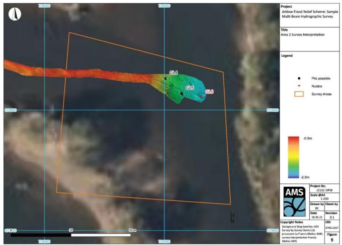
GL6 in Area 2 was identified as a small upstanding feature measuring 0.3m by 0.3m and 0.16m high over the surrounding riverbed and is interpreted as a possible rubble mound.
Fourteen possible moorings were identified, all in Area 1: GL7, GL8, GL10, GL20, GL21, GL24, GL25, GL27, GL30, GL31, GL32, GL33, GL34, and GL35. These consist of features located between 0.84m and 2.25m below the surface and ranging in size from 0.23m and 4.98m long and 0.22m and 2.93m wide and standing between 0.08m and 0.8m above the surrounding riverbed. These moorings generally appear to be small rubble mounds, in some case with ropes leading to the surface (GL7, GL8, and GL10), or as upstanding square features. These are located in groups of up to seven (GL25), or individually, and measure between 0.23m and 1.25m long, 0.23m and 1m wide, and stand between 0.08m and 0.8m above the surrounding riverbed
Three possible piles were identified: GL4, GL5 in Area 2, and GL9 in Area 1. These were between 1.05m and 1.7m below the surface, and range in size from 0.62m to 1.31m long, 0.16m to 0.5m wide, and between 0.18m and 0.75m high above the surround riverbed. (Plates 6 & 7)
A survey identified a possible pipe (GL19), partially buried, and buried at the eastern end, in Area 1, at a depth of 1.28m below the surface. This pipe is 5.45m long, 0.56m wide, and protrudes 0.25m above the surrounding riverbed