2023:080 - Petitswood, Mullingar, Westmeath
County: Westmeath
Site name: Petitswood, Mullingar
Sites and Monuments Record No.: WM019-077 and WM019-077001
Licence number: 23E0035
Author: Jacinta Kiely
Author/Organisation Address: Eachtra Archaeological Projects, Lickybeg, Clashmore, Co Waterford
Site type: Adjacent to a ringfort and souterrain
Period/Dating: N/A
ITM: E 645432m, N 752719m
Latitude, Longitude (decimal degrees): 53.522472, -7.314871
Andrews Construction Ltd are making an application to Westmeath County Council for a Largescale Residential Development (LRD) at Petitswood, Mullingar, Co Westmeath. Eachtra Archaeological Projects Ltd undertook pre-development archaeological testing at the site. Geophysical testing (23R0060) was undertaken at the site by JM Leigh Surveys in advance of the archaeological testing. There two archaeological sites, a ringfort (WM019-077) and a souterrain (WM019-077001), located on the eastern boundary of the site.
The site is bordered to the north by the Dublin Road R392 and to the east by Ardmore Road and to the west by the residential area Petitswood Manor. It is divided into four fields, which are used for pasture. The land is marginal and damp in places with a lot of rushes growing. The northern three fields run parallel to one another. There is an area of peat at the southern end of field 3 to the immediate west of the area of the ringfort and souterrain.
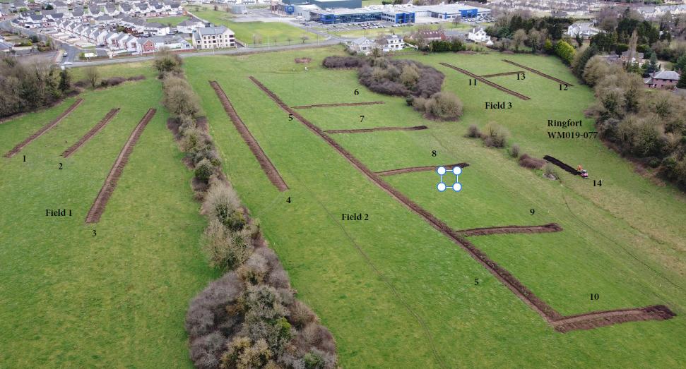
A total of sixteen trenches were excavated by machine on the footprint of the proposed development site (Plate 1). The trenches were excavated by track machine using a flat bucket.
The topsoil in Trenches 1-10 was 0.3-0.4m in depth and included fragments of glazed pottery, blackware fragments, glass and red brick dating to the late 19th century and 20th century. This is an indication that farmyard manure which encompassed household waste was spread as manure on the fields in the past. The subsoil was a fairly uniform brown-grey silty clay with a large proportion of decaying limestone with the exception of the eastern end of trenches 6-10 where peat was recorded. Faint traces of plough furrows orientated north-west/south-east were recorded in Trenches 1 & 2.
Trenches 11-13 were excavated in the northern part of field 3. The topsoil was 0.3-0.4m in depth. Few modern inclusions were recorded in the topsoil. The subsoil was a fairly uniform brown grey silty clay.
Trench 14 was excavated in the lower (southern) part of field 3. The subsoil comprised peat which was also recorded in the lower (eastern) sections of trenches 6-10. Two trenches were excavated in the western portion of field 4. The subsoil was 0.2-0.3 in depth in Trench 15. The subsoil was a peaty clay. The ground in Trench 16 consisted of dump material which probably originated from nearby developments and had been spread on this portion of the field.
No archaeological stratigraphy, features or artefacts were recorded in any of the sixteen test trenches that were excavated in the area of the proposed development site. Some evidence of recent agricultural activity which comprised traces of plough furrows, fragments of glazed pottery, blackware, red brick and glass were recorded in the trenches in fields 1 & 2 in particular. An area of peat and a dried (or drained?) water course was recorded in the low ground at the eastern edge of field 2 & the southern portion of field 3 in the area to the west of the ringfort.
Few geophysical anomalies were recorded during the geophysical survey. None of them were found to be archaeological in nature.

