2023:827 - CROBALLY UPPER, Tramore, Waterford
County: Waterford
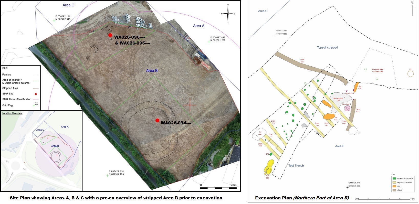
Site name: CROBALLY UPPER, Tramore
Sites and Monuments Record No.: WA026-094, WA026-095, & WA026-096
Licence number: 22E0266 ext.
Author: Grace Fegan & Philip Kenny; Shanarc Archaeology Ltd.
Author/Organisation Address: Unit 39A, Hebron Business Park, Hebron Road, Kilkenny
Site type: Excavation - miscellaneous
Period/Dating: Multi-period
ITM: E 658440m, N 602372m
Latitude, Longitude (decimal degrees): 52.170070, -7.145670
Archaeological excavations were carried out in association with the development of a housing scheme in the townland of Crobally Upper, Tramore, Co. Waterford.
The site was previously subjected to a geophysical survey under licence no. 20R0045 carried out by Joanna Leigh, which identified a number of anomalies including a possible enclosure in the south-east part of the development site. The results of the geophysical survey informed the location for test trenches, which were excavated in November 2020 by Aegis Archaeology Ltd. under licence no. 20E0596. The enclosure (WA026-094—-) identified in the geophysical survey was confirmed by testing as being the remains of a circular enclosure of likely prehistoric date, measuring 30m in diameter with a surrounding ditch measuring 1.4m in width and 0.7m in depth. The interior contained a shallow charcoal-filled pit. Two circular cremation pits (WA026-095—- & WA026-096—-) were also identified approximately 40m north of the enclosure.
The report recommended that the cremation pits be preserved by record and the enclosure preserved in situ or subject to full archaeological excavation. The report also recommended that an area beginning 50m east of the west site boundary (later labelled Area A) be the subject of pre-construction archaeological monitoring. Archaeological topsoil stripping of Areas A & C was subsequently conducted by Shanarc Archaeology Ltd. under excavation licence no. 22E0266; no archaeology was found during monitored topsoil stripping.
A licence extension to cover archaeologically-directed topsoil removal within Area B was then granted to expose the nature and extent of the previously identified archaeology within this area. Two discrete areas of archaeological activity were identified within the stripped area. A circular enclosure comprising a bank and external ditch was identified in the south-western portion of Area B. A number of cremation pits (14 possible), hearths (3 possible) and pits/post-holes were identified in an area measuring 25m x 25m in the north-eastern portion of Area B.
Excavation of the northern part of Area B was undertaken between July and August 2023. Excavation was confined to a 50m x 25m area at the north end of Area B. Approximately 80% of the features in the area had been archaeologically resolved when excavation ceased. A total of seventy-five samples were taken. The final phasing, interpretation and description of the recorded archaeology will be heavily dependant on the results of archaeobotanical and osteological analysis of these samples.
Ash Spread: A defined spread of compacted clay and ash, measuring 6.4m x 6m, was recorded but not excavated in the northeast of the site. The spread was truncated by cremation pits and by the stake-holes of Structure 2.
Cremation Burial Ground: Thirty one cremation/burnt pits were identified. A concentration of larger pits was noted in the centre of the excavation. Two of the cremations were contained within inverted banded urns. All of the cremation pits were fully excavated, with 100% samples taken of each fill.
Structures: Two possible structures were identified. Structure 1 was a small sub-square hut. It was c.1m square. The north, east and west sides of the structure were defined by a 0.03m-wide line of charcoal. The south side was made of a line of four stake-holes. The floor of the hut was a compacted clay. Structure 2 was a possible sub-rectangular hut c.1.5m to the north of Structure 1. It was c.2.6m x 2m and was made of ten stake-holes.
Ditches: Two ditches may have formed an enclosure around the cremation burial ground. The ditches were shallow. A gap between the termini of the ditches at the east side of the site may have been an entrance.
Pits: Three large pits were partially excavated. All three pits were over 0.6m deep and were irregular in profile and were backfilled with mixed dumped deposits. The pits may be associated with the ash spread.
Kiln: A probable kiln was partially excavated at the west end of the site. The kiln was defined by a cut with fire-reddened clay. A metalled surface had been laid along the north side of the kiln. Several sherds of prehistoric pottery were recovered from deposits surrounding the kiln.
Finds: The pottery assemblage comprises of c.250 sherds of mixed date, including pottery of medieval and prehistoric date. The stone object assemblage comprises 12 pieces of flint, with a further small assemblage retrieved during post-excavation work. Fifteen fragments of clay pipe were recovered.