2023:884 - Castletown, Portroe, Tipperary
County: Tipperary
Site name: Castletown, Portroe
Sites and Monuments Record No.: TN019-001001-
Licence number: 23E0936
Author: Graeme Laidlaw; Shanarc Archaeology Ltd.
Author/Organisation Address: Unit 39a, Hebron Business Park, Hebron Road, Kilkenny
Site type: Castle - unclassified
Period/Dating: Undetermined
ITM: E 573407m, N 681562m
Latitude, Longitude (decimal degrees): 52.884280, -8.395116
Archaeological test-excavations as part on an Archeological Impact Assessment relating to the proposed development of an extension to a two-storey dwelling at Castletown, Portroe, Co. Tipperary, were carried out on 3 November 2023. The site is located within the grounds of a castle/fortified house [TN019-001001-], which is largely upstanding and is prominent within the property.
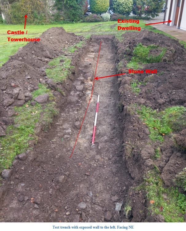
Testing comprised the excavation of a single 10m long, 1.6m wide test-trench to the west-northwest of the existing dwelling, in the footprint of the proposed extension.
Topsoil was present to a depth of 0.25-0.3m. The topsoil was a moderately compact silty clay with frequent inclusions of metal artefacts and red-brick fragments. The natural subsoil was a mixed pale yellow to light grey moderately compact silty clay. It contained moderate amounts of small and medium-sized sub-rounded pebbles. The natural subsoil was overlain with an extremely compact mid-grey clay with frequent stone inclusions.
The remains of a stone wall, 7.05m long and with a maximum width of 0.73m, was identified within the northern portion of the trench; it extended out of the trench to the north-north-east. The wall consisted of mostly unworked stones, although an occasional piece had been squared off. The stones were a maximum of 0.53m x 0.36m x 0.18m in size and were bonded with a pale creamy light-brown soft, degraded lime mortar. It contained frequent inclusions of small stones and pebbles throughout. At the north-north-east end of the wall several large boulders are incorporated into it. Two courses of the wall survived, to a maximum depth of 0.28m. A 0.85m wide gap was identified 2.5m from the south-south-west terminus of the wall. There was compact material in between, with two flat stones upon it, which may have been the remnants of a flagstone floor. The wall appears to represent the remains of a structure shown on first-edition OS map.