2023:542 - BALLYWEELIN AND ROSSES UPPER, Sligo
County: Sligo
Site name: BALLYWEELIN AND ROSSES UPPER
Sites and Monuments Record No.: N/A
Licence number: 23E0407
Author: Alan Healy, Archaeological Management Solutions
Author/Organisation Address: Fahy’s Road, Kilrush, Co. Clare, V15 C780
Site type: No archaeology found
Period/Dating: N/A
ITM: E 563357m, N 839984m
Latitude, Longitude (decimal degrees): 54.307290, -8.563047
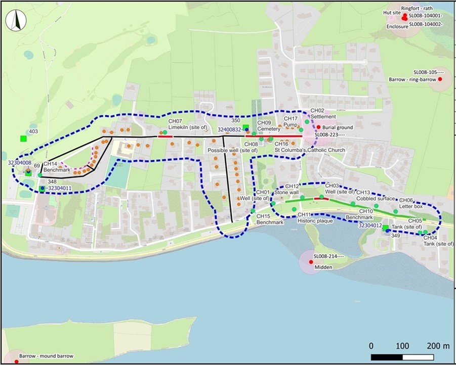
The Rosses Point Cast Iron scheme, Co. Sligo, forms part of a larger nationwide Water Network Programme that is being undertaken by Uisce Éireann. The Rosses Point Cast Iron scheme involved the installation of 452m of new water mains and 170m of proposed mains along existing road. The scheme also included the decommissioning of 1,494m of pipeline and 59 transfers of service. The groundworks for the scheme consisted of a series of exploratory trenches (access pits). The construction techniques used included slip-lining and open-cut trenching. Archaeological monitoring was recommended along the easternmost 175m of the planned decommission route, including service transfers, as the works were adjacent to the Zone of Notification of a site listed on the Sites and Monuments Record (SMR), SL008-223 (burial ground) and a settlement (CH02) depicted on the first-edition six-inch Ordnance Survey map (1837).
Archaeological monitoring also took place in the vicinity of several cultural heritage (CH) sites including a cemetery (CH09), the sites of two wells (CH03; CH08) and the site of a limekiln (CH07) and 20m either side of these.
An Access pit for service tappings was monitored on a section of the route where the slip-line installation method was used, located in the vicinity of the site of a well (CH03). The road surface measured 0.3m deep and consisted mostly of made ground with natural subsoil visible in section comprising a light yellowish-brown silty clay.
Access pits for service tapping from the existing main were excavated in the vicinity of several CH sites including the possible site of a well (CH08), a cemetery (CH09) and St Columba’s Catholic Church (CH16). These trenches comprised made ground onto existing pipes and the replacing of old services with new. The made ground was found generally under approx. 0.2m road surfaces.
Another open-cut trench for Connection 4 was monitored in proximity to a burial ground (SMR SL008223) and settlement CH02 comprising made ground found under approx. 0.2m of road surface, on top of older service pipes.
No potential archaeological objects, features or deposits were revealed in any of these trenches.