2023:089 - CARTRONAGOR (3), Roscommon
County: Roscommon
Site name: CARTRONAGOR (3)
Sites and Monuments Record No.: N/A
Licence number: E5207
Author: Joe Nunan and Brigid Melloy, AMS
Author/Organisation Address: Fahy's Road, Kilrush, Clare
Site type: Structure
Period/Dating: Modern (AD 1750-AD 2000)
ITM: E 582470m, N 787722m
Latitude, Longitude (decimal degrees): 53.838691, -8.266344
Cartronagor 3 was excavated in advance of construction of the N5 Ballaghaderreen to Scramoge Road Project in County Roscommon by Archaeological Management Solutions (AMS) for Roscommon County Council (RCC) and Transport Infrastructure Ireland (TII). The structures appear on the first-edition six-inch Ordnance Survey map (1838) and on the 25-inch OS map (1914) and were recorded in the Environmental Impact Assessment Report as CHC36 (Roughan & O’Donovan-AECOM 2017, 304). The subsurface remains of a vernacular structure and ancillary structures were subsequently identified during Stage (i)a Standard Test Excavations, carried out by AMS under Ministerial Direction (Direction No. A077, Registration No. E5070) (Hardy 2021).
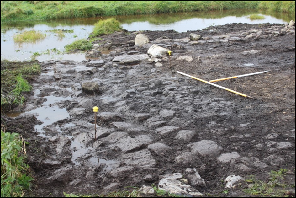
Excavation at the site uncovered the remains of three vernacular structures interpreted as a dwelling and two outbuildings.
Structure A comprised a west-north-west/east-south-east-orientated arrangement of three sections of wall and an internal metalled surface. Externally the structure measured 3.6m by 3.2m and internally it measured 2.8m by 1.3m. Two metalled surfaces were located to the north and south of the structure walls, respectively.
Structure B was located c.3m to the west of Structure A and comprised a north–south arrangement of wall sections and internal metalled surfaces. Externally the structure measured 10.6m by 4m and internally it measured 9.2m by 1.8m. No evidence for doors, fireplaces or other such features survived in Structure A or Structure B.
Structure C, the possible dwelling, was located in Area B, c.10m southwest of Area A, and comprised an east–west oriented, L-shaped arrangement of two discontinuous sections of wall with three metalled surfaces and a layer of mortar. The structure measured 3.15m long by 6.5m wide. No evidence for doors, internal divisions or other such features survived in Structure C.
Four sherds of post-medieval pottery, one piece of glass and a button were recovered from Cartronagor 3. They were dated to the late nineteenth–twentieth centuries. One sherd of pottery represented the base of an egg cup and was stamped ‘MADE IN GERMANY’, indicating an international import.
References
Hardy, C. 2021. N5 Ballaghaderreen to Scramoge Road Project Stage (i)a, (i)b, (i)c Test Excavation, Stage (i)m Testing in Felled Forestry and Stage (i)f Townland Boundary Survey. Ministerial Direction No. A077, Registration No. E5070. Unpublished AMS report for TII and RCC.
Roughan & O’Donovan-AECOM. 2017. N5 Ballaghaderreen to Scramoge Road Project Environmental Impact Assessment Report. TII and Roscommon National Road Design Office. Available at: http://www.roscommoncoco.ie/en/Services/Roads/Publications-and-Information/N5-Ballaghaderreen-to-Scramoge-Road-Project/Environmental-Impact-Assessment-Report/Volume-2B-EIAR-Chapter-11-19/00-EIAR.pdf. [Accessed 18 November 2021].