2023:814 - STALEEN AND OLDBRIDGE, Donore, Meath
County: Meath
Site name: STALEEN AND OLDBRIDGE, Donore
Sites and Monuments Record No.: ME020-078, ME020-077
Licence number: 23E0005
Author: Brendon Wilkins, DigVentures
Author/Organisation Address: 5 Witham Studios, Hall Street, Barnard Castle, Co. Durham, UK
Site type: Pit alignment, Cist burial, Ring-ditch and Causewayed enclosure
Period/Dating: Multi-period
ITM: E 704320m, N 773879m
Latitude, Longitude (decimal degrees): 53.704170, -6.420003
Excavations were undertaken in 2023 for a community-based archaeological research excavation at Donore, County Meath. Fieldwork formed part of The Boyne Valley Research Project—a partnership led by DigVentures in collaboration with Dr Steve Davies, UCD School of Archaeology. The project builds on an earlier collaborative large-scale geophysical research project between the Romano-Germanic Commission (RGK), Frankfurt and UCD School of Archaeology.
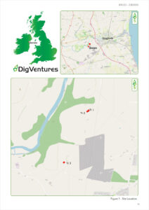
Location of Trenches 1 and 2 (Oldbridge townland) and Trench 3 (Staleen townland)
Three hand-dug trenches were excavated to explore and characterise geophysical survey results to address a combination of archaeological research and heritage management questions.
Trench 1 (10m x 4m) investigated geophysical anomalies denoting a small enclosure and potential demolished megalithic structure immediately adjacent to an extant standing stone. The resulting excavation was a highly unusual mix of modern and prehistoric archaeology leading to a potentially unique artefactual discovery—an embossed brass plaque bearing what was essentially an excavation report from 1889, describing the discovery of a cist burial.
This artefact—archaeology of the archaeologists—has helped to shape a narrative sequence making sense of the disturbed mix of prehistoric and modern features. A decorated stone slab, potentially originating from a Neolithic chambered tomb, was reused as a capstone for a Bronze Age cist burial. The cist contained a single adult, interpreted as male in 1889, but as yet unverified, along with a decorated urn. Following repeated plough strikes, the farmer attempted removal of the stone—and once the archaeological nature of the site became evident, the cist was then excavated as a ‘controlled’ investigation under the patronage of Lt Col Coddington. Once the contents of the cist were removed, a stone-roofed structure was erected above to protect and display the site—remaining in place till at least 1909 when it was included on Ordnance Survey Meath Sheet 20 map. At some point between 1889 and the present, information relating to the site was lost or misplaced and no RMP entry was accurately created for the site.
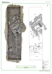
Plan of Trench 1, Oldbridge townland, showing the excavated features.
Trench 2 (3m x 5 m) focussed on a possible post/pit alignment within the possible ritual complex, adjacent to the enclosure/structure. Trench 2 was located to intersect one of 35 similar pits identified in geophysical survey within a double-row. The pits appear to align towards Dowth Henge, sited 1km away to the west-northwest. One of the pits excavated in the 2023 field season comprised a large, round, u-shaped cut into the natural bedrock measuring 1.95m by 1.2m with a depth of 0.93m. The remnants of a disturbed post were visible, with a jagged, disturbed cut indicative of deliberate removal in antiquity. This measured 0.92m by 1.02m and 0.95m deep, containing several charcoal-rich deposits and burnt bone. C14 results from charcoal recovered from the truncating pit returned a date from the Late Neolithic/Chalcolithic period (2573–2350 cal BC).
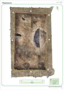
Plan of Trench 2, showing the excavated pits and identified
Trench 3 (12m x 5m) investigated a large, ditched enclosure with significantly elevated magnetic properties indicative of burnt material incorporated into a large enclosure. Geophysical, topographic and photogrammetric survey revealed the line of a potential causewayed enclosure following a visible break of slope around the top of Donore Hill—a natural feature likely to have been intentionally enhanced by the original monument builders. The earliest feature in Trench 3 was the terminus of a substantial ditch [3002] cut into the natural bedrock, matched by a corresponding ditch terminus identified on the opposing side of the trench. These results were consistent with the geophysical survey and the character of a probable causewayed enclosure. Although no artefactual evidence was recovered from the feature, datable material was retrieved through palaeoenvironmental samples. C14 results from charcoal recovered from the ditch returned an Early Neolithic date (3751–3533 cal BC).
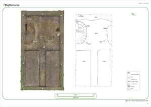
Plan of Trench 3, Staleen – termini of possible causewayed enclosure